Train tunnels, tracks, and miscellaneous stuff
A general catalog of pictures of tunnels and train-related items in Southwest Virginia, Kentucky and East Tennessee. The main focus is on the original Clinchfield line from Elkhorn City KY to the Tennessee/North Carolina state line, but we’ve got our eyes on that remarkable 6-tunnel looped line near Little Switzerland NC.

Dry Fork tunnel #4
We’re just off Hwy. 627 about a mile south (as el cuervo flies) of Bandy VA. This tunnel is centered at 37.128412, -81.699718. It appears to be about 501′ long. There’s a trestle a little bit past this northern portal that goes over 627, but, since I lost my notes on this journey, I don’t recall the date on the trestle. Btw, I’ve replaced both the voice recorder and the eTrex with newer models. I tried them out last Sunday as we explored the old town of Bulls Gap…first railroad there was built by slave labor in 1857.

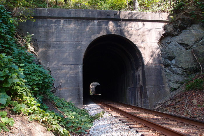
Dry Fork #5
We started in Cedar Bluff VA, working our way up the N&S line toward Rift WV. There are five tunnels along the way. It was a hot day. I ended up taking a belly slide down the shaley embankment off a rail line (I was nearly to the top of the 35′ embankment when the loose dirt crumbled away from my foot and down I went, clutching a small tree that I had grabbed, hoping for a little braking, but I got breaking) and getting a fair amount of scratches (two on the lens of my Nikon, prompting my buddy to remind me about, you know, a skylight filter to protect the lens…). Then, to top if off, a few tunnels on, I absent mindedly left my Olympus voice recorder and my eTrex on the trunk of my car and then drove away. God knows where they are. But, I’ve got replacements ordered. Paraphrasing a saying by my boss, “If you’re going to be stupid, you’ll have to pay.”
This is Dry Fork tunnel #5, centered at 37.109438, -81.723611. This is looking more or less south. By the Google Earth ruler, it appears to be about 790′ long. 1912 date, as you can see. This line could be far older than this date, since N&W could have done a full refurb of the line in 1911-1912 (there are these dates firmly on trestles and tunnels on this line), facing the tunnels and replacing old timber trestles.


#37 Vance tunnel
Here’s the requisite picture of Vance tunnel (35.895091, -82.024390, 2721′ elevation, 527′ long), just across a ditch and a fill from Altepass Baptist Church (can’t miss it, there’s a big red caboose sitting across from the church). These tandem engines are heading back toward Tennessee.


Here, however, is a shot of the above portal, showing the 1907 date. Once I’d scrambled up the fill to the track and trotted down to get this pix, I turned around and saw that I could have just as easily walked in from a crossing just up the way. But, then, there’s some romance somewhere in carefully stepping across a green, slightly greasy, little stream and then, crab-like, making my way up a fill. Most of the time it works fine…

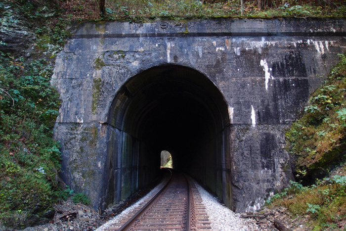
#34 Free Hill tunnel
Gray, TN, used to be called “Gray Station”. There was a train station right about where the big telemarketing building is now. Just to the east of that location is the 41′ or so narrow ridge that the railroad had to tunnel through to maintain grade. Thus: what is known now as Free Hill tunnel. It’s a 472′ jobbie that quite a few people who work and live around the area don’t even know is there (and they probably don’t care, either). There are also two single-lane concrete railroad overpasses in the area, indicating that there were extant roads in the early 1920s (they also carry 1927 dates). But they didn’t carry a lot of traffic, or cars were a heck of a lot narrower then. Anyway, here’s the tunnel’s EC (west) portal.
 tunnel EC side")
ET&WNC tunnel #5 Doe River Gorge
If you come in to Doe River Gorge from Railroad Grade Road, you can easily walk right past this former east portal of tunnel #5. It’s completely covered over and only the remains of the cut can be seen…look:

The west portal is partially open, but filled with rather murky looking water. Wonder what lives in there? Anyway, that’s my hiking buddy providing scale for this opening:

From this tunnel on, the line went on up to the fabled magnetic iron mines at Cranberry NC and, for a while, on to Boone. That’s another story, told in several locations.
ET&WNC tunnel #5 Doe River Gorge
If you come into the Gorge from the Railroad Grade Road side, this one’s easy to miss. The west portal of tunnel #5 is completely filled in and only the remains of the cut can be seen…look

ET&WNC tunnel #4 Doe River Gorge
The 4th tunnel heading toward North Carolina in Doe River Gorge is just past a dilapidated deck truss bridge over the Doe River. It’s crossable. Careful, though. The tunnel is centered at36.250708, -82.156534 and it’s filled with water. (read the comment on this)


There are two bridges over the Doe in the Gorge. One still has a truss superstructure, but precious little else and the other is as described above.
ET&WNC tunnel #3 Doe River Gorge
As you progress up from the Baptist Ministry, you’ve passed tunnel #2 and you’ve seen Pardee Point


That’s Pardee Point…carved out in the 1880s (looking back toward the Ministry). Ario Pardee was one of the owners of the ET&WNC from 1879 to 1882. Thought you’d like to know.
Here’s tunnel #3


Lots of ice…and it was slippery! But the view was, well, spectacular!


ET&WNC tunnel #2 – Doe River Gorge
This is the second tunnel on the line heading away from Johnson City up through Doe River Gorge. It’s centered at 36.265916, -82.171331.

My hiking buddy, clad in plastic against the cold, January rain, is standing in the western portal. This part of the line is intermittently active during the summer for excursions from the Ministry.
ET&WNC Tunnel #1
Traveling out of Elizabethton on 19E to Hampton, as you begin to cross the first bridge over the Doe River, look to your right. Down below is the first tunnel on the fabled ET&WNC railroad. Find someplace to do a uie, come back, do another uie and park off the highway just before you get to the main bridge. You can walk on down and you’ll see this very decrepit and probably dangerous, former auto bridge over the Doe. It crosses the Doe over to where the tunnel is. Here it is:

It was kind of cold that day. I am standing (that’s not me on the bridge) with the tunnel behind me, looking westerly. Here’s the tunnel:

It’s not all that long, but it was a cloudy day and you can’t see the other portal. The concrete to the left is a conduit for telephone lines or something. The thing on the right is a container of some sort. The line went through here (coming from Johnson City) and on down the Doe, up Doe River Gorge and out again near Hopson. There are several tunnels in this stretch of line. I’ve got pix. Coming up.
Not a tunnel, but…
It’s interesting. This is at 36.09553, -83.251823. “Why,” you say, “that’s on Douglas Lake!” Right again, swami.

This is a long abandoned rail line (now under someone’s backyard, as you can see) that wyed off and went slightly east of another line heading in a more southerly direction. This line went across a high point in the lake (some call them islands, but they’re really just the tops of hills) and on to a now isolated and rusting through truss bridge over the French Broad River. The railway must have been mightily upset with TVA back in 1941-42, when they realized that a dam was going to be built which would impound a lake (officially a reservoir) that would cause them to do costly rearranging of their lines in the area. It annoyed many other people for other reasons, but, it was wartime, and the government needed electricity. These structures remain as reminders that this was once a fertile, much loved valley with creeks and hills and farms. Did you ever read about the lead-up activities to the Five Gorges Dam in southern China? Same thing.
Nice lettering, though.
Skaggs Hole tunnel, reboot
When I first posted Skaggs Hole tunnel, I didn’t know how much I wasn’t seeing. We had to be up in the Bartlick area anyway (my buddy had spotted some old mines on the topo and wanted to check them out…luckily, they were mostly intact and he got his pictures), so I took the chance to walk down and redo the tunnel. First, some maps show it as “Skegg’s Hole” and some “Skaggs Hole”. Let’s let the highway department decide the issue:

There now. On to the tunnel. This is the south face looking toward the bridge over the Russell Fork. The tunnel, 519′ long, centers at 37.256522, -82.327300.

Note the date on the lintel is 1931. This is when the railroad made some significant improvements to this tunnel. A culvert just behind where I’m standing has a set-in-concrete (seriously) date of 1913 and the bridge beyond also has a date set in the abutment concrete of 1913. This is when the tunnel was cut out and jibes with Goforth’s date range for the Elkhorn City extension of the Clinchfield. This is looking out of the north face of the tunnel to the bridge over the river.


Here’s the north portal, wide view, showing Skagg’s Hole, which I believe is a deep area in the river to the left at this bend. You can just see the river, about 30′ below.

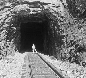
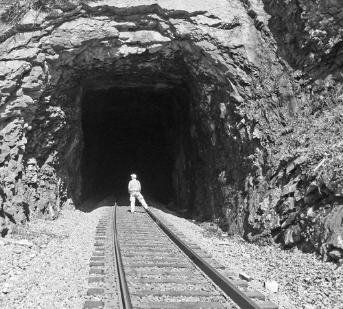
#35 Indian Ridge tunnel
This is the last tunnel in Tennessee as the CSX heads east to North Carolina. This is Indian Ridge tunnel, in Johnson City. It’s 1.023′ long and centers at 36.345467, -82.424185. This is looking westerly. It was a sunny day, so the ballast and the ties (or “sleepers”, as they call them in the UK) overexposed a bit. Notice that the ties are concrete. And a fair number of them were badly cracked.
It was hard to get to this tunnel. We had to park about a half-mile away and carefully walk down the side of a fairly busy road that had no generous shoulders. Then we had to scramble (there’s a lot of scrambling when it comes to getting to tunnels and bridges) down to the cut. The date is 1912 on the facing. Squint hard, you can see it.

Callahan’s Nose tunnel
Callahan is a common name in this area. There’s a Callahan Avenue in Appalachia and a Callahan Creek that’s near here. I assume that is the origin of the name of this tunnel.
Anyway, this is the other tunnel on that old (1890) Fremont branch of the L&N line that ran from Appalachia to Big Stone Gap. It’s been unused since 1986 or so.
This is Callahan’s Nose tunnel from the Appalachia side:

The short, 135′ tunnel is centered at 36.884670, -82.786329.
This is the south face. The overpassing track is active N&S.

I took these when I was more interested in the pleasant hike from Appalachia to Big Stone Gap than I was the tunnels, but I took one picture because I was surprised at the brick interior of this tunnel (below). I suspected that it showed that the tunnel was an older one and, surprise, I was right. Bricking was an earlier technique of shoring up a tunnel. After the turn of the century, they generally used concrete to ensure the integrity of a tunnel. Enlarge the picture and you can clearly see the brick.


Blair tunnel
This is Blair tunnel on the N&S going north out of Richlands VA.
 The junction is called Jewell (Jewell Ridge is just across Hyw. 67 to the right of this picture. This southern portal is at 37.179843, -81.796229. The tunnel is about 3,000′ or so long and comparatively new. Anecdotal evidence suggests it was built around 1967 or so. One person told us it dated “from the 60s” and the dates on the pony plate bridges leading up here are all 1968.

Here’s a closer look at the portal


There’s a sign that says “Blair” on the right. The large plaque thing below it is blank. The tunnel overhead is strongly supported by anchor bolts, but some of the concrete has broken away and there’s a fair amount of water leakage. The rails here are lightly used and the waiting tracks all were rusted.
From here, this line heads northwesterly to Vansant and points west.
Bee Rock tunnel
In 1890, the Louisville & Nashville railway (L&N) pushed two tunnels through outcroppings of Stone Mountain between Appalachia and Big Stone Gap while creating its Cumberland Valley Division. This one, closest to Appalachia at 36.895712, -82.787822, is Bee Rock.


This is the view from the Appalachia side. The tracks are still in place, but they haven’t seen a train since around 1986. Bee Rock, at 47′ 7″ in length, enjoyed a brief fame as the “Shortest Railroad Tunnel in Use in the United States”, according to Ripley’s Believe it or Not. Soon (oops!), someone noticed that there was a tunnel a foot or so shorter over near Gallatin TN and that was that.
This is looking through the tunnel toward Callahan’s Nose tunnel (about 4,000′ ahead), which we’ll come to later (interesting tunnel, that).


The plans are, I believe, to turn this old railbed from Appalachia to Big Stone Gap into a trail for walking and biking. I hope so. I’ve walked it a couple of times. It’s very enjoyable, but, then, I’m easy. I’ve walked a lot worse rail lines, for sure.
#33 Kendrick tunnel
We’re just north of the intersection of Highway 36 and Moreland Drive, near Colonial Heights (centers at 36.491976, -82.504663). The railroad goes under Ft. Henry Drive (Highway 36) and into this 502′ tunnel, completed in 1912. Walking up to the tunnel, you can easily see how the highway overpass was added to when Ft. Henry Drive was taken to four lanes. Interestingly (to me), the railroad concrete bridge over Reedy Creek in Kingsport is dated 1907, and it’s on this line. North first, south later, I guess. Gray tunnel, also known as Free Hill tunnel, is next, close to the now long gone Gray Station. See you there.


#32 Holston tunnel
If you’d been hanging out around this area in, say, 1777, you would have seen a fort down near the river, at a location that’s probably been obliterated by Tennessee Eastman or the plant that preceded it. That would have been Fort Patrick Henry (nowhere near the dam that carries the name). However, the tunnel wouldn’t have been here, since it was completed in 1913 or so. There are just three more tunnels in Tennessee before the rail line heads into the Appalachian Mountains (and that’s ap-UH-latch-ian, not ap-UH-lace-ian) (’round here). This tunnel is 154′ long. First is the western portal, then a look back at the eastern portal. A bridge here (which can be clearly seen on Google Earth) overlooks the old Kingsport waterworks and the never-completed 3-C railbed. Over the river and on to Colonial Heights.


Sandy Ridge tunnel (the other one) – north portal
Finally! Thanks to diligent map work by my hiking buddy, a way was found to get to this northern portal of the other Sandy Ridge tunnel. It wasn’t easy. It was a bumpy drive down a long graveled road, across a strip mine, then down to the valley floor. After that, there was about 100′ to drop from the road to the last ledge before getting to the rail bed (the rails are long gone), then maybe 30′ down hanging from saplings and stretching to reach a foothold…from which I slipped and got my butt all muddy and wet (drove home sitting on a sheet of plastic…not the first time, either). Then, there was a slog through mud and running water to get just close enough to the portal to take the picture below. Not shown is the cataract coming down the right-hand side of the mountain…lots and lots of water. 1958 is the date on the lintel. Oh, and the climb back up the rock cut was even more fun. But I got the picture. Enjoy. Later note: I went back to near the tunnel entrance (I wasn’t even going to get down into that cut again) to do a proper GPS reading (my Garmin had, for some unknown reason, reset to a weird map datum the last time). Here it is: 37.037311, -82.189956. Going on back down the road, we found a place where a side road joins the railbed, now a rather dicey road of its own. The second picture is looking back toward the tunnel from the intersection. You would have problems walking in to the tunnel from here because of the large growths of wild roses and the average annoying briars. Back behind me, the road continues for maybe a half mile or so and ends at a strip mine. 


Whitesburg KY tunnel
There used to be an L&N rail line through Whitesburg KY. It’s gone now (the rails were pulled up in the late 80s), but this one tunnel and several deck girder bridges (constructed in 1912) remain. This unnamed tunnel (at 37.114941, -82.812306, more or less…couldn’t get an exact reading, since the tunnel cut is too narrow to allow a GPS reading and it’s difficult to see where the west portal is on Google Earth) is east of Whitesburg, near the city water works, through a ridge called “Tunnel Hill”. All the rails are gone and the tunnel is muddy as the Maytown tunnel is. It’s also short, maybe 150′ max. The first picture (say hello to Ranger, who manages to get in nearly every picture), is of the western portal (it’s unfinished, as is the eastern portal) and the next picture is looking out towards the east. It was just too wet to get through to the portal itself. The railbed from this tunnel on into Whitesburg (a neat little town) has been converted into a greenbelt. Judging by the rivet patterns on the bridges, the trains must have carried a fair amount of coal out of this area. (tip of the hat to Patty Hawkins and Lina Tidal of the Harry M. Caudill Library in Whitesburg for some of this information)


#31 Sensabaugh tunnel
Located through Sensabaugh Ridge at 36.577409, -82.625001, this bendy little (348′) tunnel is about a half mile south of Click tunnel, on the other side of Sensabaugh Valley, just a hop, skip and a jump from Beartown. We’re almost 89 miles from Elkhorn City. This view is looking south. I found a really nice piece of quartz near here, but I didn’t keep it. “Oh, joy, another piece of quartz.”
#30 Click tunnel (now in color)
Early in the process of laying out the route of the railroad, engineers had to determine where to build trestles and where to fill in to keep the track on a steady grade. When they came to the valley carved between Click Ridge and Sensabaugh Ridge, they opted to fill. They built a concrete underpass over Sensabaugh Hollow Road and Sensabaugh Branch (it runs through the underpass). Then, using the rock hewn out of the ridges for Click and Sensabaugh tunnels, they fashioned a 30′ or so high fill to keep the trackage at roughly 1300′ above sea level. The fill spans the distance from Click tunnel and Sensabaugh tunnel (coming up next). Coming out of Virginia into Hawkins County, you hit Click tunnel at 88.2 miles from Elkhorn City at 36.584876, -82.630481. The tunnel is 608′ long and apparently has the original facing set in 1913. There are stories about the road tunnel below the track being haunted, but, from what I hear, the locals think that’s hooey. This picture was taken looking northward, with Sensabaugh tunnel to my back.

#29 Clinch Mountain tunnel (now in color)
Clinch Mountain tunnel, in Scott County VA, at 36.637520, -82.735412 (center top of tunnel), is 4,135′ long. The date on the lintel is 1909. If you have hawk-keen eyes, you might just be able to see the tiny speck of white near the bottom of the tunnel opening…that’s the other end. It’s unfaced and just across Highway 23 from the Vulcan quarry in Speers Ferry, over a girder plate trestle. The next picture is back on the Kermit side of the tunnel, just off to the right. These are the ruins of a factory that was extant here in the early years of the last century. It mined sand from up on the Clinch Mountain, processed it, and shipped it Pittsburgh Glass. Odd to find that here…maybe it was super duper sand, or something. Remnants of the rail siding are still visible (not in the picture)(sidings aren’t particularly interesting).
As of October, 2013, the ruins of the factory are still much the same, but heavily overgrown. And, just as the last time, as I was taking this picture series (I’m just posting one), a CSX mixed-unit train came rolling through, generating enough wind in the cut to nearly take my cap off.

Here’s the north portal of Clinch Mountain tunnel:

#28 Speers Ferry tunnel
This tunnel is just west of Gate City VA at 36,647391, -82.744457. It’s 1,116′ feet long and has an odd-looking south portal, kind of skewed. Just back toward the highway from the tunnel is a quarry that you shouldn’t mess with, but is really an interesting place. With this tunnel, we’re nearing the Tennessee line. Up next, the 4,135′ Clinch Mountain tunnel, with an associated surprise.

Craigan Tunnel, St. Paul
Backing up a little bit to St. Paul VA, this is Craigan Tunnel (you can’t see the sign on the right side of the portal very well, but it states the tunnel name as “Creagan”) at 36.902711, -82.328600. The tunnel is about 900′ or so long. The date on the tunnel lintel is 1905. It was part of the Interstate line then, now it’s a N&S property. There was a huge fire in this tunnel in September of 1903 that required the St. Paul fire department, along with others, to build dams at either portal of the tunnel and pump it full of water. We started to walk through this tunnel, but decided not to. Good plan, that. Just as we climbed over the tunnel, a N&S double locomotive coal train came rolling through. 

#27 Bald Knob tunnel
We’re at the 78 mile marker (as you can see) now, at the natural portal of Bald Knob tunnel. The tunnel centers at 36.6666080, -82.750432 at about 1400′ elevation. It’s 453′ long and is about 1900′ southwest of Clinchport tunnel. While the former Clinchfield line bored through Bald Knob, the N&S (old Southern) ran their line closer to the Clinch River and avoided having to tunnel. I speculate that the unusual configuration of the rock, the near vertical face on the left) around the tunnel entrance precluded finishing it off with concrete. This is looking roughly south.

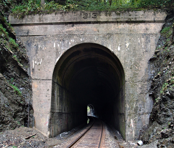
#26 Clinchport tunnel
We’re a little more than 77.5 miles south of Elkhorn City at Clinchport tunnel, actually near Boulder VA. The railroad here crosses SR 644 on a 1929 overpass (shown). Tunnel is at 36.671713, -82.745216 and is 637′ long. The first picture is looking south and the second picture is looking north with the lintel of the tunnel clearly showing the 1913 date. This was two years before the Clinchfield Railroad was officially completed. 


Swede tunnel (the real Swede tunnel)
My buddy always suspected that this was Swede tunnel (also called Beverly tunnel, according to Ed Wolfe in his book on the Interstate Railroad), located at 36.919845, -82.449835 on the Guest River Gorge Trail. I thought that Swede was the tunnel located in Coeburn (see that post), but, thanks to a comment from a viewer, I was corrected. I think this tunnel, the only one on the Guest River Gorge Trail, is about 200′ long. This is looking down the trail.

#24 and #25: The Twins
Located in Scott County VA, where the Clinch River makes a wide bend, these two tunnels bypass it by cutting through two close ridges. The North Twin (308′) is 71.26 miles south of Elkhorn City (quickly vanishing in the distance, well over the horizon, lost in Kentucky). The South Twin is just a few feet beyond the North. If you were standing between them, you’d be at 36.709679, -82.646909 and an elevation of 1343′. South Twin is just 236′, a mere slip of a tunnel. The first picture is the south portal of South Twin, looking north to the North Twin. The second picture is the north portal of North Twin, looking south to the north portal of South Twin. They’re both dated 1912.