

L&N railroad
Evarts KY
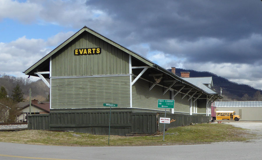
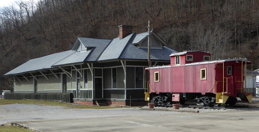
Two views of the refurbished train station at Evarts KY, near Harlan. It cleaned up quite nicely. The first Post Office opened in this town in 1855. Since the L&N came into Harlan in 1911, I assume that the railroad came through here soon after, as it made its way east into the coal country.
Glenbrook
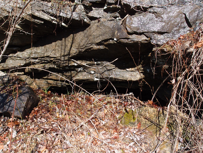
In 1947, the L&N ran the Clover Fork Branch up to what was called Glenbrook KY (read about it here). The reason was that Stonega Coal and Coke Company had decided to dip into the Wallins coal seam here. They constructed five dated adits as they dug into the coal. This one at 36.88345, -82.91997 is representative of the three on the eastern part of this complex (it’s not really open…there’s a huge, rusty fuel tank stuffed into the adit to deter visitors):

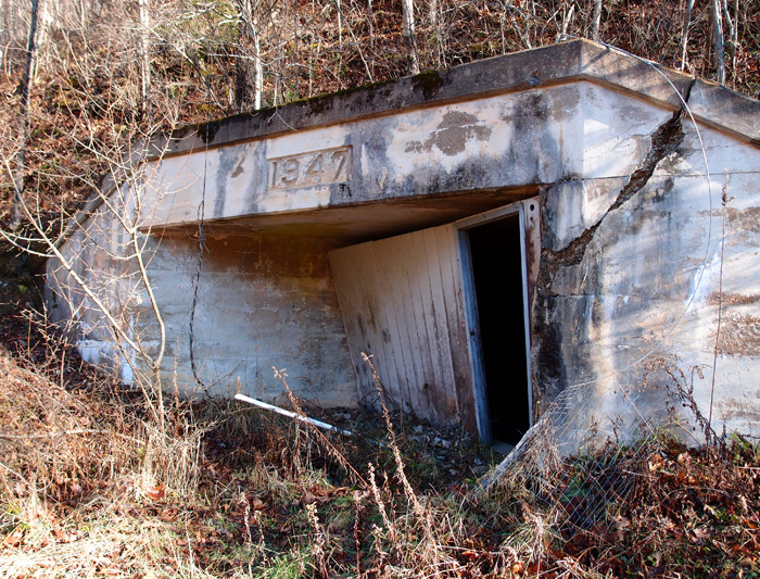
Right at these adits is a group of buildings…a service area for mining equipment, a power building, showers and lockers for the miners. There were also offices installed sometime later, since they put in dropped ceilings to cover the original high ones with the pulleys that helped miners get out of their work clothes before showering.
On the west side of this particular complex are two more adits, also dated 1947:

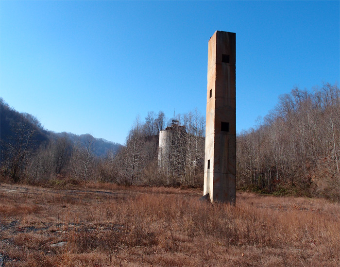
Here’s a long view of what was once a sorting/loading area:
And this possibly was once a very early exploratory mine, now bermed in. You can easily tell is was once a mine, though:
This whole old mining area is in foreclosure. It’s scheduled to be completely bulldozed early in 2015. We took plenty of pictures. We’ll remember it.
Another Anonymous Tunnel
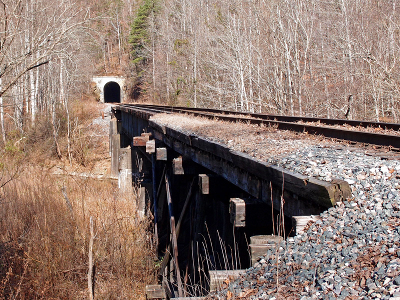
I opted to show the approach and the tunnel because the tunnel isn’t particularly interesting. No date, but it was constructed in the 1940s when the L&N opened up the Leatherwood Branch (KY) to bring out coal from the massive Blue Diamond Mine complex. This portal is at 37.09080, -83.10304. The tunnel, a little over .25 mile long, curves through a ridge at a bend of Leatherwood Creek. The track here actually dates to 1940, mostly Bethlehem Steel rail. There are two trestles here: the closest is timber construction and the far one is deck girder, with no maker name/date plate. It didn’t appear to have ever had such a plate.
This is looking easterly. The track curves to the right practically at the portal. The line then goes on to what is now a partial wye over the North Fork of the Kentucky River down at the end of Dent Yard.
Harlan KY
This is a 1910 Louisville Bridge and Iron Company pony girder just off 421 going into Harlan from the south. CSX now owns this former Louisville & Nashville bridge over Martin’s Fork River. Beyond the bridge you can see the huge door that closes off this area in the event of flooding (which Harlan was very susceptible to)…it’s part of a 5,000′ long wall that protects the city from rising water. The flooding used to be worse, before they cut the three large tunnels to divert the Clover Fork River to near Baxter (see the tunnels here).
Bridge over Martins Fork (KY)
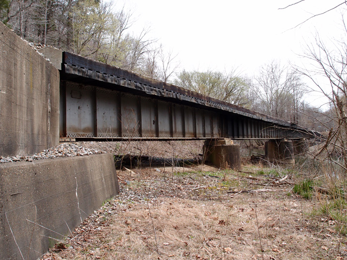
This is one of three deck girder bridges over Martins Fork in Harlan County KY between Chevrolet and Cawood. They were constructed in 1928 by the Bethlehem Steel Company in Bethlehem PA. This line is active CSX, but I suspect the line was put in by the L&N. There’s a spur line, now dead, just north of here at Lenarue that parallels (sort of) Hwy 990 up to the Mary Helen mines.
This particular bridge is just off Hwy 3001 over Martins Fork. It’s about 280′ long.
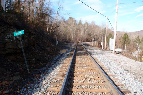
Dorchester Junction
On a trip up to the Norton/Wise area of southwest Virginia, my buddy wanted to see if we could locate the now mostly forgotten Dorchester Junction, an interchange point for the Interstate Railroad and the L&N at 36.926574, -82.659993. Interstate came east from Kent Junction, crossed over here and headed on up to Dorchester and Needmore. All that’s left of the old Interstate line is the railbed and this abutment and leads to the actual Dorchester Junction:

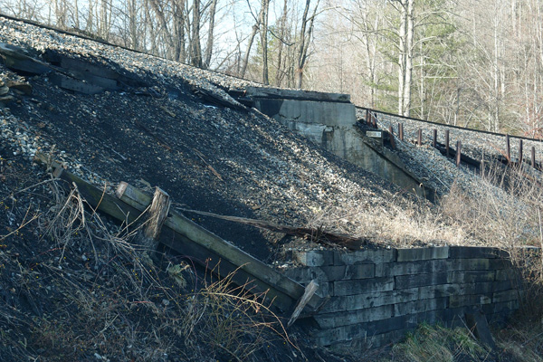
This area is named “Dnor” now. The abutment is right where my buddy is standing.

The trestle, made of timber, crossed the valley here over to where the new highway runs now.

Here are some of the remnants of the old trestle, lying beside the now stripped railbed:


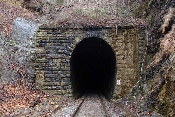
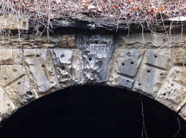
Cumberland Gap tunnel (the old one)
This is the last tunnel on the line coming out of Knoxville. As I’ve mentioned before, the Knoxville Cumberland Gap Louisville railroad company blasted out this tunnel in 1888-1889, with a grade going up to the more or less center of the tunnel on both sides, so the cross-section of the mountain would reveal a tunnel that looks like an inverted “V”. Smoke had a tendency to collect at the top and make breathing difficult for crews and passengers. Then, to add to the woes, the tunnel collapsed on July 4, 1894, and again in 1896. Engineers didn’t like to go into the tunnel, so they’d push a string into the tunnel and have another locomotive pull it out from the other portal. Passengers had to take a wagon ride through the gap. This wasn’t a good situation. When L&N gained control of the tunnel (KCGL had gone bust in 1892), they did a complete refurb ending in 1897, which is the date on this portal (this is mostly from “History of the Louisville & Nashville Railroad” by Maury Klein). It’s also the date that “Dracula” by Bram Stoker, was published. When the tunnel was begun, the Buffalo Soldiers were active in the West, just 7 years after the gunfight at OK Corral.
(I’m proud of this blog. Someone came in and lifted a lot of the text above the picture. The text ended up, with no credit, scrolled in purple (!) on another website.)
If you’d like to see a great video taken from a locomotive of a trip through this tunnel:
long and narrow
Here’s a closer look at the date on the lintel:
The Oakman tunnels
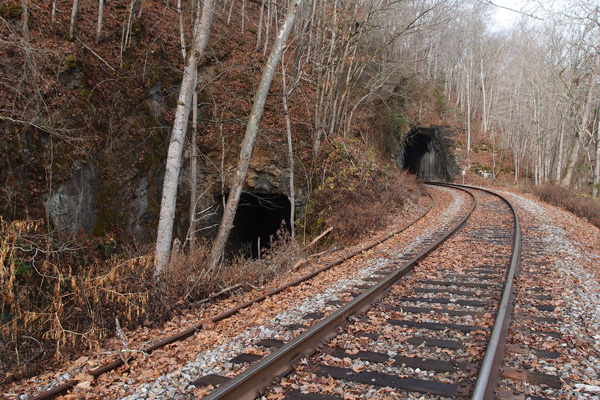
In the late 1800s, the Powell’s Valley Railroad made ambitious plans to run a line from Knoxville to Cumberland Gap. This was in the waning heyday of Middlesboro KY, just on the other side of the Gap (Middlesboro sits in a meteor crater, btw). The L&N was already in Middlesboro and was looking to get through the Gap to extend their line southward. When the Powell’s Valley Railroad became the Knoxville-Cumberland Gap-Louisville railroad, the L&N talked them into blasting a tunnel through the Gap. On the way from Knoxville, though, the line had to cross the Clinch River at this location. A tunnel was dug through the ridge and a bridge was built and all was well…until TVA began to construct Norris Dam, which was completed in 1936. The Southern Railroad, which now owned the line, realized that their trackage here was too close to the water line, so a new tunnel and a new bridge had to be constructed. These two portals are at 36.363018, -83.550292. The new tunnel is about 330′ long. There was an historic community called “Oakman” about a mile to the southwest of this tunnel. It’s gone, but the tunnel isn’t. That’s how it goes sometimes. We’ll take a look at the other side next.

Crummies Creek tunnel
Between 1924 and 1931, a narrow-gauge railroad hauled coal from the Crummies Creek mines to a prep plant on the other side of the mountain on Cemetery Road near Crummies, KY*. This portal, probably dynamited and then filled in, is near 36.78559, -83.21749. Good luck trying to find it on Google Earth. We nearly missed it ourselves. When I took this picture, I was standing on top of the fill looking into the tunnel right at the top. I could feel cool air blowing out, so the tunnel’s not completely filled in.
On the prep plant side, there were several L&N lines that used a double-track loader. The tracks are gone now.

*The Kentucky place name list tells me that a “crummy” or “crummie” refers to an animal that has crooked horns.
Callahan’s Nose tunnel
Callahan is a common name in this area. There’s a Callahan Avenue in Appalachia and a Callahan Creek that’s near here. I assume that is the origin of the name of this tunnel.
Anyway, this is the other tunnel on that old (1890) Fremont branch of the L&N line that ran from Appalachia to Big Stone Gap. It’s been unused since 1986 or so.
This is Callahan’s Nose tunnel from the Appalachia side:

The short, 135′ tunnel is centered at 36.884670, -82.786329.
This is the south face. The overpassing track is active N&S.

I took these when I was more interested in the pleasant hike from Appalachia to Big Stone Gap than I was the tunnels, but I took one picture because I was surprised at the brick interior of this tunnel (below). I suspected that it showed that the tunnel was an older one and, surprise, I was right. Bricking was an earlier technique of shoring up a tunnel. After the turn of the century, they generally used concrete to ensure the integrity of a tunnel. Enlarge the picture and you can clearly see the brick.


Bee Rock tunnel
In 1890, the Louisville & Nashville railway (L&N) pushed two tunnels through outcroppings of Stone Mountain between Appalachia and Big Stone Gap while creating its Cumberland Valley Division. This one, closest to Appalachia at 36.895712, -82.787822, is Bee Rock.


This is the view from the Appalachia side. The tracks are still in place, but they haven’t seen a train since around 1986. Bee Rock, at 47′ 7″ in length, enjoyed a brief fame as the “Shortest Railroad Tunnel in Use in the United States”, according to Ripley’s Believe it or Not. Soon (oops!), someone noticed that there was a tunnel a foot or so shorter over near Gallatin TN and that was that.
This is looking through the tunnel toward Callahan’s Nose tunnel (about 4,000′ ahead), which we’ll come to later (interesting tunnel, that).


The plans are, I believe, to turn this old railbed from Appalachia to Big Stone Gap into a trail for walking and biking. I hope so. I’ve walked it a couple of times. It’s very enjoyable, but, then, I’m easy. I’ve walked a lot worse rail lines, for sure.
Whitesburg KY tunnel
There used to be an L&N rail line through Whitesburg KY. It’s gone now (the rails were pulled up in the late 80s), but this one tunnel and several deck girder bridges (constructed in 1912) remain. This unnamed tunnel (at 37.114941, -82.812306, more or less…couldn’t get an exact reading, since the tunnel cut is too narrow to allow a GPS reading and it’s difficult to see where the west portal is on Google Earth) is east of Whitesburg, near the city water works, through a ridge called “Tunnel Hill”. All the rails are gone and the tunnel is muddy as the Maytown tunnel is. It’s also short, maybe 150′ max. The first picture (say hello to Ranger, who manages to get in nearly every picture), is of the western portal (it’s unfinished, as is the eastern portal) and the next picture is looking out towards the east. It was just too wet to get through to the portal itself. The railbed from this tunnel on into Whitesburg (a neat little town) has been converted into a greenbelt. Judging by the rivet patterns on the bridges, the trains must have carried a fair amount of coal out of this area. (tip of the hat to Patty Hawkins and Lina Tidal of the Harry M. Caudill Library in Whitesburg for some of this information)


