Clevinger Branch Tunnel

This is a CSX Clevinger Branch Coal Run subdivision (read about it here) tunnel near Clevinger Branch Road (3227), about 3 miles NE of Coal Run Village in Pike County KY.  Coordinates (at center) are 37.5519, -82.5239.  It’s about 1,500′ long on an active line.
Inside the tunnel, the ties are concrete:


The ballast is covering the center of the ties.  I’ve seen flat (and cracked) concrete ties at the Indian Ridge tunnel in Johnson City, but none like these. Interesting.

Robinson Creek Tunnel

This tunnel at Robinson Creek KY (37.38180, -82.54229) was in the news in April, 2014, when two arsonists set the thing on fire.  The fire burned for weeks and the ceiling of the tunnel collapsed.  The arsonists were discovered and now face federal charges.
The tunnel is 700′ long and dates back 100 years.  It’s on an active CSX line that serves two coal mines.
Here’s what it looks like inside:

I’m told it took major work to get the tunnel back in operation.

Pine Mountain tunnel, west portal

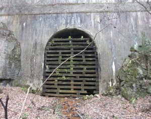
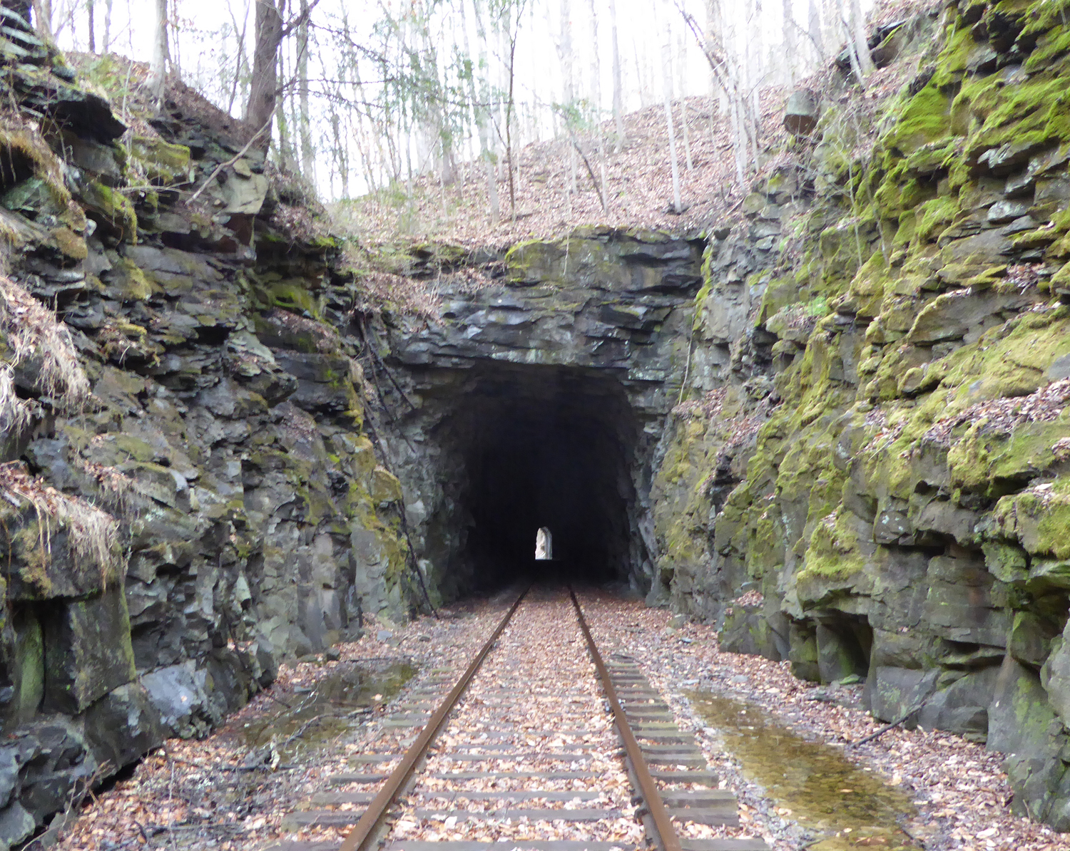
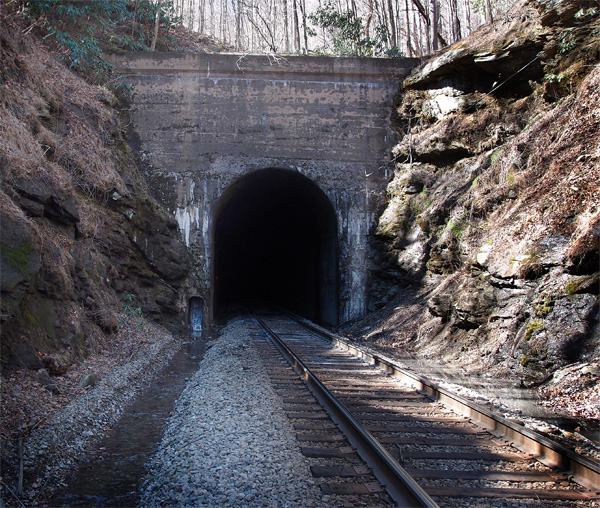
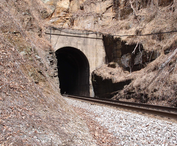
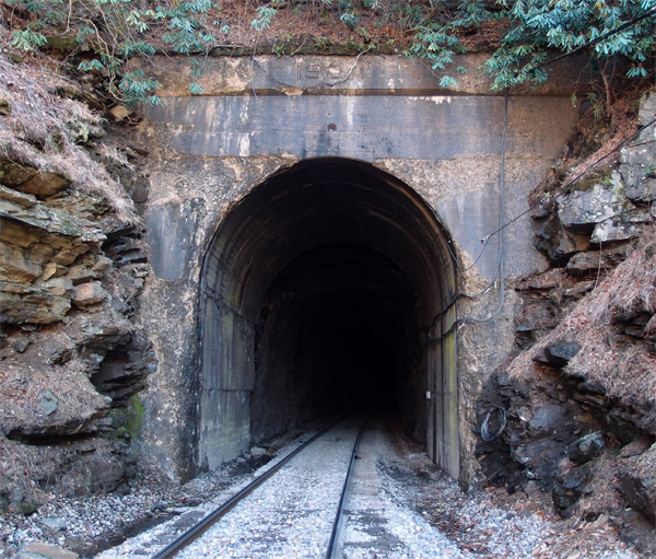
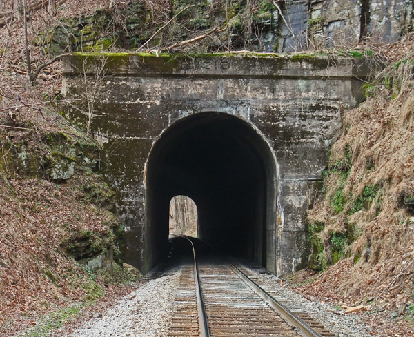
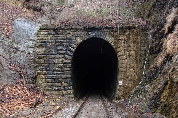
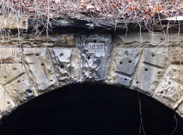
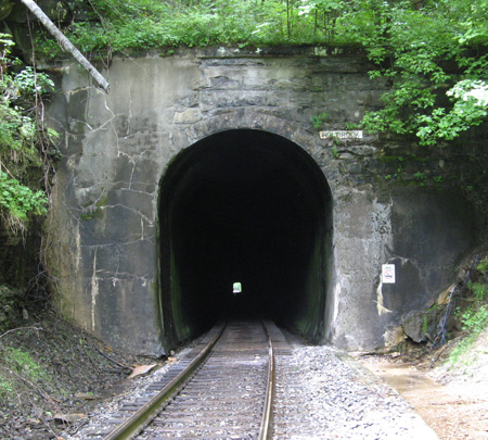
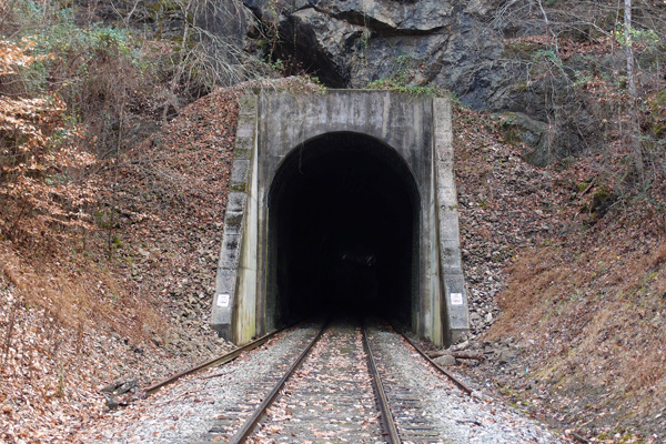
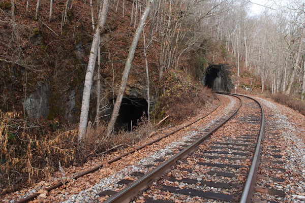
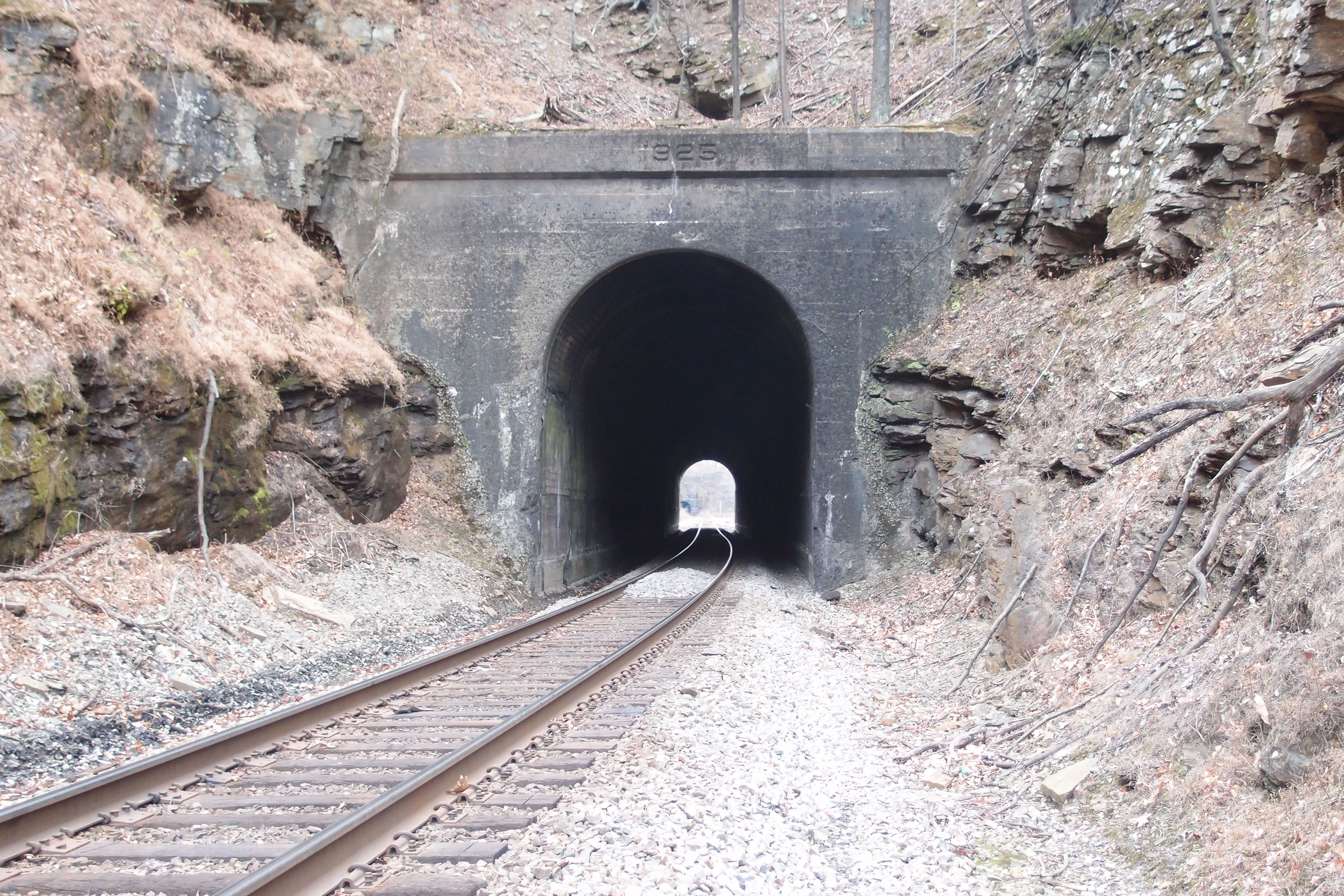
Just a couple of days ago, a person who had visited this blog sent me some extremely valuable information on the Pine Mountain tunnel, bored in 1947-1948 from Jenkins KY over to the Virginia side of Pine Mountain.  The C & O was eager to open up a vast, 300 million ton, coal field just east of Pound.  The tunnel was completed in 1948 and was out of service by 1958.  The east portal, which I’ve posted before, is more or less open, if you like slogging in waders to get through to it.  This west portal, near Jenkins, was boarded up rather thoroughly (although I’ve had at least one person comment that they had gone through it).  Thanks to a photo by Chris Balthis, I know that this portal is well reinforced with concrete.  The literature indicates that this side of the mountain wasn’t as stable as the east side.  Look closely and you’ll see the inscription above the tunnel.  They did things like that then…now they just throw tunnels up and slap some concrete on them.  Hmmph, kids these days…
Anyway, I thought I’d posted this western portal.  I hadn’t.  Error corrected.
pinemtntnnlwestportal

#54 Marion tunnel

Here we are at Marion tunnel, the northern portal (35.688458, -81.980895),  a little over 219 miles from Elkhorn City KY on the CSX.  This is the final tunnel on the line.  It’s pretty much all flat land from here to Spartanburg SC.  Marion tunnel is 1,073′ long and the lintel date is 1913, which means it’s probably original to the tunnel.   That’s a CSX locomotive coming out of the tunnel, heading up into The Loops.  Although this ends my project to document all the tunnels on this CSX line, there’s more to come.

OLYMPUS DIGITAL CAMERA

#53 Honeycutt tunnel

This eastern portal of Honeycutt tunnel is at 35.86638030, -81.969960.  The tunnel is 1,688′ long and about a half mile or so west of the Ashford Cut.  The reface date on the lintel is 1923. This, of course, is the penultimate tunnel on the line from Elkhorn City KY and Marion NC.  I stood and looked at this tunnel for quite a few minutes, knowing this was the end of an over two-year project to document these tunnels.  This was the last tunnel to be photographed, since we had gone into Marion two weeks earlier and had recorded the tunnel there.  My buddy walked over to an outcropping over to the right of  the line, back about 50′ or so, to investigate what appeared to be a cave.  It wasn’t, but he found two stone cairns there.  Since this tunnel is relatively isolated, I wonder if they were piled up by the workers here in 1907 – 1908.  Could have been grave markers, too, since many men, often foreign labor, died blasting out these tunnels and doing the hard labor of laying a railroad.

OLYMPUS DIGITAL CAMERA

The Loops: 2nd Rocky

Just about 770′ to the south of 1st Rocky is 2nd Rocky.  It’s 757′ long. This south portal is at 35.865584, -82.004314.  The date on the refurb portal is 1918. You have to get permission to cross private land to get to both 1st Rocky and 2nd Rocky and there are two ways to get to them after that.  Fairly easy.  4th Rocky is a long trek away.  Believe me.

OLYMPUS DIGITAL CAMERA


This is the northern portal of 2nd Rocky.  The date is partly eroded. I can see 192, but the fourth numeral is gone.

OLYMPUS DIGITAL CAMERA


Cumberland Gap tunnel (the old one)

This is the last tunnel on the line coming out of Knoxville.  As I’ve mentioned before, the Knoxville Cumberland Gap Louisville railroad company blasted out this tunnel in 1888-1889, with a grade going up to the more or less center of the tunnel on both sides, so the cross-section of the mountain would reveal a tunnel that looks like an inverted “V”.  Smoke had a tendency to collect at the top and make breathing difficult for crews and passengers. Then, to add to the woes, the tunnel collapsed on July 4, 1894, and again in 1896.  Engineers didn’t like to go into the tunnel, so they’d push a string into the tunnel and have another locomotive pull it out from the other portal.  Passengers had to take a wagon ride through the gap.  This wasn’t a good situation.  When L&N gained control of the tunnel (KCGL had gone bust in 1892), they did a complete refurb ending in 1897, which is the date on this portal (this is mostly from “History of the Louisville & Nashville Railroad” by Maury Klein). It’s also the date that “Dracula” by Bram Stoker, was published.  When the tunnel was begun, the Buffalo Soldiers were active in the West, just 7 years after the gunfight at OK Corral.

OLYMPUS DIGITAL CAMERA


(I’m proud of this blog.  Someone came in and lifted a lot of the text above the picture.  The text ended up, with no credit, scrolled in purple (!) on another website.)
If you’d like to see a great video taken from a locomotive of a trip through this tunnel:
long and narrow


Here’s a closer look at the date on the lintel:

OLYMPUS DIGITAL CAMERA

Holbrook tunnel

The third tunnel between St. Paul and Coeburn is Holbrook.  It centers at 36.924873, -82.372080 and is about 1,600′  long.  A trestle begins 11′ or so inside the northwestern portal and extends 625′ over a valley.  It’s dated 1947, but, since the tunnel was blasted out around 1905, we know it’s a replacement for the original timber trestle (and it must have been some trestle!).  There are two more trestles before we get to Coeburn, both high and long.

holbrook

Greer tunnel

This is the last tunnel on what is now the mostly abandoned N&S line coming from Knoxville to Cumberland Gap.  This is Greer tunnel, close to a feature called “Greer Lake”  (not seeing a Greer Lake, folks) and New Tazewell.  This portal, the northwest, is at 36.423103, -83.591183.  The tunnel, soggy and drippy, seems to be about 350′ long.   The history of this railroad and the changes in its trackage provide interesting reading.
OLYMPUS DIGITAL CAMERA

Sycamore tunnel

We were faced with a dilemma.   We knew we didn’t want to cross the trestle coming out of Oakman tunnel over Norris Lake because it is a bare-bones trestle, with no provision for any foot traffic.  Although the line is, for all intents and purposes, dead, we were still leery of being on a rather exposed stretch of tracks.  So, we walked back to our vehicle and drove around to Lone Mountain marina and hiked in to Sycamore tunnel from there.  This north portal is at 36.378498, -83.562599.  The tunnel, which has a bend,  is around 740′ long.  The south portal looks much like this one and, after 260′ or so, heads out over another narrow trestle.

OLYMPUS DIGITAL CAMERA

The Oakman tunnels

In the late 1800s, the Powell’s Valley Railroad made ambitious plans to run a line from Knoxville to Cumberland Gap.  This was in the waning heyday of Middlesboro KY, just on the other side of the Gap (Middlesboro sits in a meteor crater, btw).  The L&N was already in Middlesboro and was looking to get through the Gap to extend their line southward.  When the Powell’s Valley Railroad became the Knoxville-Cumberland Gap-Louisville railroad, the L&N talked them into blasting a tunnel through the Gap.  On the way from Knoxville, though, the line had to cross the Clinch River at this location.  A tunnel was dug through the ridge and a bridge was built and all was well…until TVA began to construct Norris Dam, which was completed in 1936.  The Southern Railroad, which now owned the line,  realized that their trackage here was too close to the water line, so a new tunnel and a new bridge had to be constructed.  These two portals are at 36.363018, -83.550292. The new tunnel is about 330′ long.  There was an historic community called “Oakman” about a mile to the southwest of this tunnel.  It’s gone, but the tunnel isn’t.  That’s how it goes sometimes. We’ll take a look at the other side next.
OLYMPUS DIGITAL CAMERA

2nd Cawood tunnel

This tunnel, fairly short, is south of the Cawood KY tunnel on Bob’s Creek at 36.766159, -83.242214 (this is the north portal. The south portal is unfinished).  A man who lives near this tunnel, after checking our religious credentials (we lied)(sorry), confirmed that the 1929 date on the tunnel is consistent with the building of this line.  He also regaled us with stories of at least four people who died on the railroad for various reasons (drunk, stupid).  That stuff rolls off our backs like duck water.

Tunnel near Cawood KY

This is the southerly portal of a long, 1/4 mile or so, tunnel on the CSX near Cawood KY.  Anecdotal evidence (I’m still doing research) indicates that this line was laid down in the late 20s, but the date on this portal, if there ever was one, has been eroded away.  This portal is at 36.77949,  -83.24325.  A picture of this on Google Earth is titled as being near “Bob’s Creek”.  Not my creek, no sir.

Crummies Creek tunnel

Between 1924 and 1931, a narrow-gauge railroad hauled coal from the Crummies Creek mines to a prep plant on the other side of the mountain on Cemetery Road near Crummies, KY*.  This portal, probably dynamited and then filled in, is near 36.78559, -83.21749.  Good luck trying to find it on Google Earth.  We nearly missed it ourselves.  When I took this picture, I was standing on top of the fill looking into the tunnel right at the top. I could feel cool air blowing out, so the tunnel’s not completely filled in.
On the prep plant side, there were several L&N lines that used a double-track loader.   The tracks are gone now.


*The Kentucky place name list tells me that a “crummy” or “crummie” refers to an animal that has crooked horns.

Natural Tunnel VA

You know about Natural Tunnel, right?  If not, here’s the Wiki.  And here’s a picture of same, complete with the N&S track that’s been there for over a hundred years:


But, wait! There’s more! Because, in railroad design thinking, it’s usually better, more costly, but better to ram through than go around, there’s another tunnel just a little bit south of the main, naturally formed (of course) one.  Here ’tis (this is the northern portal…(kinda looks like they just sawed through the rock, no?):

Pounding Mill tunnel #1

We’re about halfway between Cedar Bluff and Claypool Hill in Tazewell County VA.  This is on an N&S line from Bluefield to Norton.  It’s the first of three.  It’s centered at 37.078360, -81.746409 and is about 545′ long.  This line came through between 1887 and 1890.  We’re heading up to the UrCoal region: Pocahontas, but we’ve got a couple more tunnels to check out.

Dry Fork tunnel #1

This is Dry Fork tunnel #1 (37.234365, -81.639281), about 470′ or so.  This is looking north from the trestle over the Rift-Berwind Road and Dry Fork River in West Virginia.  Bridge facing date is 1912, with a 1911 date on the trestle abutment.  Pending further research, I’d say the line here dates to the late 1800s, when the coal mines began to open up.  Our general theory with the lines in the area is that they blasted out the tunnels, leaving them unfinished if they were stable and ran the line over timber trestles until either the trains got heavier or the timber began to deteriorate, then they switched to the current configurations.  It’s a theory.

#34 Free Hill tunnel

Gray, TN, used to be called “Gray Station”.  There was a train station right about where the big telemarketing building is now.  Just to the east of that location is the 41′ or so narrow ridge that the railroad had to tunnel through to maintain grade.  Thus: what is known now as Free Hill tunnel.  It’s a 472′ jobbie that quite a few people who work and live around the area don’t even know is there (and they probably don’t care, either).  There are also two single-lane  concrete railroad overpasses in the area, indicating that there were extant roads in the early 1920s (they also carry 1927 dates).  But they didn’t carry a lot of traffic, or cars were a heck of a lot narrower then.  Anyway, here’s the tunnel’s EC (west) portal.

ET&WNC tunnel #3 Doe River Gorge

As you progress up from the Baptist Ministry, you’ve passed tunnel #2 and you’ve seen Pardee Point


That’s Pardee Point…carved out in the 1880s (looking back toward the Ministry). Ario Pardee was one of the owners of the ET&WNC from 1879 to 1882.  Thought you’d like to know.
Here’s tunnel #3


Lots of ice…and it was slippery!  But the view was, well, spectacular!

ET&WNC tunnel #2 – Doe River Gorge

This is the second tunnel on the line heading away from Johnson City up through Doe River Gorge.  It’s centered at 36.265916, -82.171331.


My hiking buddy, clad in plastic against the cold, January rain, is standing in the western portal.  This part of the line is intermittently active during the summer for excursions from the Ministry.

ET&WNC Tunnel #1

Traveling out of Elizabethton on 19E to Hampton, as you begin to cross the first bridge over the Doe River, look to your right.  Down below is the first tunnel on the fabled ET&WNC railroad.  Find someplace to do a uie, come back, do another uie and park off the highway just before you get to the main bridge.  You can walk on down and you’ll see this very decrepit and probably dangerous, former auto bridge over the Doe.  It crosses the Doe over to where the tunnel is. Here it is:


It was kind of cold that day.  I am standing (that’s not me on the bridge) with the tunnel behind me, looking westerly.  Here’s the tunnel:


It’s not all that long, but it was a cloudy day and you can’t see the other portal.  The concrete to the left is a conduit for telephone lines or something.  The thing on the right is a container of some sort. The line went through here (coming from Johnson City) and on down the Doe, up Doe River Gorge and out again near Hopson.  There are several tunnels in this stretch of line.  I’ve got pix.  Coming up.

Whitesburg KY tunnel

There used to be an L&N rail line through Whitesburg KY.  It’s gone now (the rails were pulled up in the late 80s), but this one tunnel and several deck girder bridges (constructed in 1912) remain.  This unnamed tunnel (at 37.114941, -82.812306, more or less…couldn’t get an exact reading, since the tunnel cut is too narrow to allow a GPS reading and it’s difficult to see where the west portal is on Google Earth) is east of Whitesburg, near the city water works, through a ridge called “Tunnel Hill”.  All the rails are gone and the tunnel is muddy as the Maytown tunnel is.  It’s also short, maybe 150′ max.  The first picture (say hello to Ranger, who manages to get in nearly every picture), is of the western portal (it’s unfinished, as is the eastern portal) and the next picture is looking out towards the east.  It was just too wet to get through to the portal itself.  The railbed from this tunnel on into Whitesburg (a neat little town) has been converted into a greenbelt.  Judging by the rivet patterns on the bridges, the trains must have carried a fair amount of coal out of this area. (tip of the hat to Patty Hawkins and Lina Tidal of the Harry M. Caudill Library in Whitesburg for some of this information)

Up in Kentucky

This tunnel, on a CSX line from a large strip mine in Myra KY, is in Virgie KY.  I backed off to show the chimney above the tunnel.  The tunnel itself has been sprayed with quick-setting concrete and has rock bolt reinforcements all along its length.  The line goes from here to the big rail yard at Shelbiana.  Once, the line went south of Myra, but it’s just empty railbed now.  There were plenty of short trestles on this line…every blessed one of them made by American Bridge Company in 1911.  The company is still in business…and so are the trestles on the active line.  The trestles on the dead line that don’t go over the 2-lane highway have been removed, but the locals say that, even though the railroad has to carry insurance on the extant trestles, they’re just too expensive to move, since they’d have to somehow reroute the traffic when the crane comes in to haul out these hunks of tonnage.

#8 Hewitt tunnel

This is Hewitt Tunnel, about 13.6 miles from Elkhorn City.  This was the most difficult tunnel for us to reach, since we opted not to wade the McClure River (it would have been easier to do that…the river’s not really deep in that area), but to drive in on a road I’d spotted on Google Earth.   The gravel road was about a mile downhill with drainage berms cut across the road a regular intervals.  I got my Honda Civic over them with minimal scraping going down, but coming back was a white knuckler as the car spun in the gravel and failed to gain traction.  With my buddy’s pushing and the little car’s gutsy (!) front wheel drive, we managed to get the job done, but my hands were shaking from adrenaline when we got back to the main road. I also found out later that all that spinning and stuff had basically destroyed my tires.  It was time for new rubber, anyway.