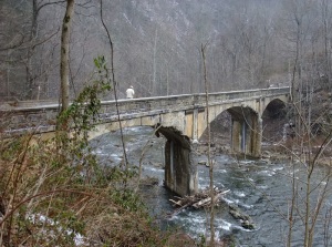
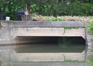
Gray, TN, used to be called “Gray Station”. There was a train station right about where the big telemarketing building is now. Just to the east of that location is the 41′ or so narrow ridge that the railroad had to tunnel through to maintain grade. Thus: what is known now as Free Hill tunnel. It’s a 472′ jobbie that quite a few people who work and live around the area don’t even know is there (and they probably don’t care, either). There are also two single-lane concrete railroad overpasses in the area, indicating that there were extant roads in the early 1920s (they also carry 1927 dates). But they didn’t carry a lot of traffic, or cars were a heck of a lot narrower then. Anyway, here’s the tunnel’s EC (west) portal.
Month: June 2012
ET&WNC tunnel #5 Doe River Gorge
If you come in to the Gorge from Railroad Grade Road, you can easily walk right past this former east portal of tunnel #5. It’s completely covered over and only the remains of the cut can be seen…look:
The west portal is partially open, but filled with rather murky looking water. Wonder what lives in there? Anyway, that’s my hiking buddy providing scale for this opening:
From this tunnel on, the line went on up to the fabled magnetic iron mines at Cranberry NC and, for a while, on to Boone. That’s another story, told in several locations.
ET&WNC tunnel #5 Doe River Gorge
ET&WNC tunnel #4 Doe River Gorge
The 4th tunnel heading toward North Carolina in Doe River Gorge is just past a dilapidated deck truss bridge over the Doe River. It’s crossable. Careful, though. The tunnel is centered at36.250708, -82.156534 and it’s filled with water. (read the comment on this)

There are two bridges over the Doe in the Gorge. One still has a truss superstructure, but precious little else and the other is as described above.
ET&WNC tunnel #3 Doe River Gorge
As you progress up from the Baptist Ministry, you’ve passed tunnel #2 and you’ve seen Pardee Point

That’s Pardee Point…carved out in the 1880s (looking back toward the Ministry). Ario Pardee was one of the owners of the ET&WNC from 1879 to 1882. Thought you’d like to know.
Here’s tunnel #3

Lots of ice…and it was slippery! But the view was, well, spectacular!

ET&WNC tunnel #2 – Doe River Gorge
This is the second tunnel on the line heading away from Johnson City up through Doe River Gorge. It’s centered at 36.265916, -82.171331.
My hiking buddy, clad in plastic against the cold, January rain, is standing in the western portal. This part of the line is intermittently active during the summer for excursions from the Ministry.
ET&WNC Tunnel #1
Traveling out of Elizabethton on 19E to Hampton, as you begin to cross the first bridge over the Doe River, look to your right. Down below is the first tunnel on the fabled ET&WNC railroad. Find someplace to do a uie, come back, do another uie and park off the highway just before you get to the main bridge. You can walk on down and you’ll see this very decrepit and probably dangerous, former auto bridge over the Doe. It crosses the Doe over to where the tunnel is. Here it is:
It was kind of cold that day. I am standing (that’s not me on the bridge) with the tunnel behind me, looking westerly. Here’s the tunnel:
It’s not all that long, but it was a cloudy day and you can’t see the other portal. The concrete to the left is a conduit for telephone lines or something. The thing on the right is a container of some sort. The line went through here (coming from Johnson City) and on down the Doe, up Doe River Gorge and out again near Hopson. There are several tunnels in this stretch of line. I’ve got pix. Coming up.
Not a tunnel, but…
It’s interesting. This is at 36.09553, -83.251823. “Why,” you say, “that’s on Douglas Lake!” Right again, swami.
This is a long abandoned rail line (now under someone’s backyard, as you can see) that wyed off and went slightly east of another line heading in a more southerly direction. This line went across a high point in the lake (some call them islands, but they’re really just the tops of hills), past a strange structure (see it at unclebobstravels.com) and on to a now isolated and rusting through truss bridge over the French Broad River. The railway must have been mightily upset with TVA back in 1941-42, when they realized that a dam was going to be built which would impound a lake (officially a reservoir) that would cause them to do costly rearranging of their lines in the area. It annoyed many other people for other reasons, but, it was wartime, and the government needed electricity. These structures remain as reminders that this was once a fertile, much loved valley with creeks and hills and farms. Did you ever read about the lead-up activities to the Five Gorges Dam in southern China? Same thing.
Nice lettering, though.


