A person who follows this blog queried me on a tunnel he’d found access to of Hwy. 83 in Dickenson County VA. I searched it out and found what it was, but I couldn’t find a blog entry about it. I’d slipped up. I thank the guy who caught this.
This is Bear Pen Gap tunnel, west portal, taken in April, 2011. In my original digital photograph, the east portal is just barely visible at 1/2 mile away. Returning to this portal today, May 24, 2015, I couldn’t see the other portal. Part of the tunnel may have collapsed. Very dangerous.
The air coming out of this tunnel today was cool enough to condense breath.
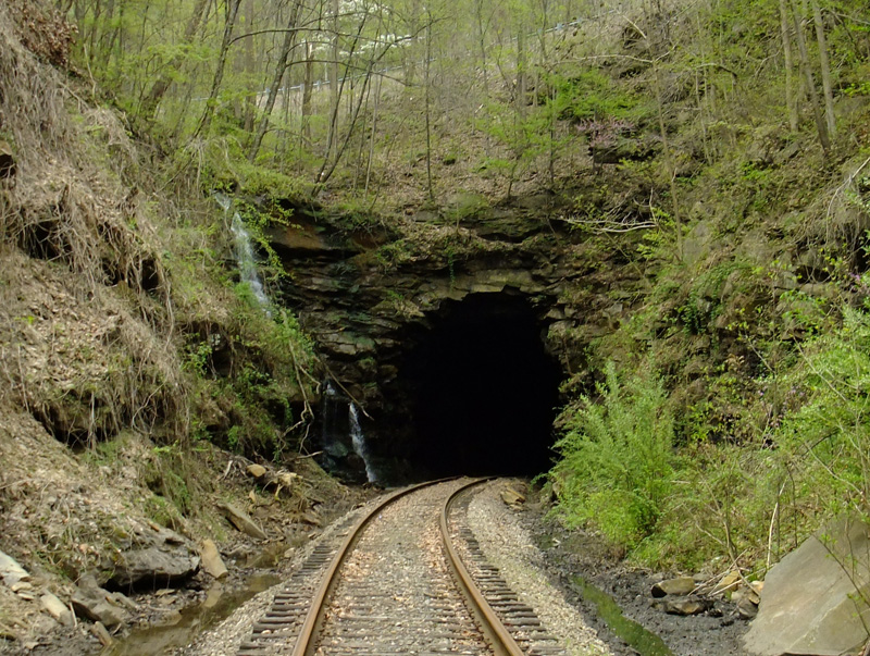
This is the east portal, taken in April, 2011. The water, as of May, 2015, was still flowing off the left side ledge. This portal is a little over a half mile from Fremont.
This was the one tunnel on the Clinchfield Railroad’s old Fremont branch, which, starting in 1947, ran from Fremont to Moss #1 mine a little over 14 miles away. The mine shut down in 1989, but this line was used for a couple more years hauling wood chips from an operation at the Moss location.
The latest rail date we saw in this area is 1972, Lackawanna.
As we walked up to this portal four years ago, a kid (maybe 13-14 years old?) came down the embankment. He was totally togged out in Army fatigues – cap to boots – and was sporting a fake pistol in a proper holster. We all nodded to each other and passed on, but my buddy and I exchanged a puzzled look. Cosplay is everywhere.
Note: a bear “pen” is a place where early settlers trapped bears and killed them for meat.
Callahan is a common name in this area. There’s a Callahan Avenue in Appalachia and a Callahan Creek that’s near here. I assume that is the origin of the name of this tunnel.
Anyway, this is the other tunnel on that old (1890) Fremont branch of the L&N line that ran from Appalachia to Big Stone Gap. It’s been unused since 1986 or so.
This is Callahan’s Nose tunnel from the Appalachia side:
The short, 135′ tunnel is centered at 36.884670, -82.786329.
This is the south face. The overpassing track is active N&S.
I took these when I was more interested in the pleasant hike from Appalachia to Big Stone Gap than I was the tunnels, but I took one picture because I was surprised at the brick interior of this tunnel (below). I suspected that it showed that the tunnel was an older one and, surprise, I was right. Bricking was an earlier technique of shoring up a tunnel. After the turn of the century, they generally used concrete to ensure the integrity of a tunnel. Enlarge the picture and you can clearly see the brick.