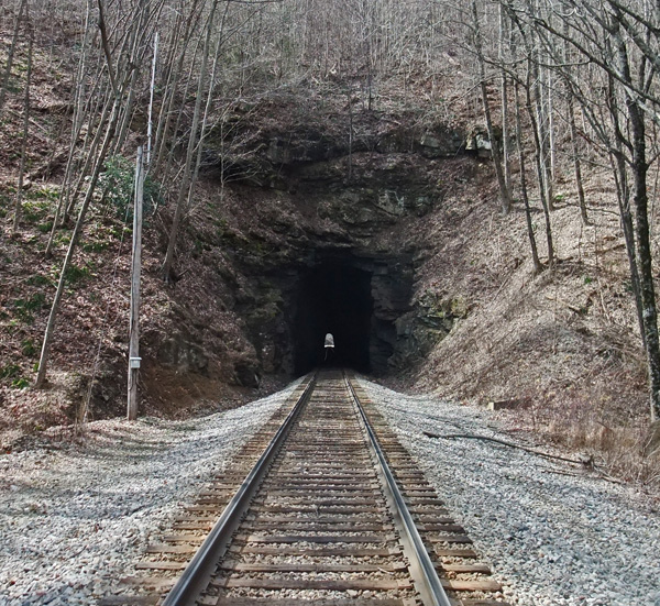
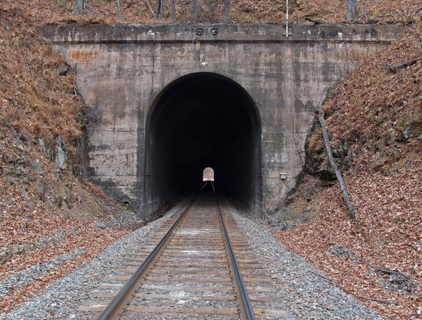
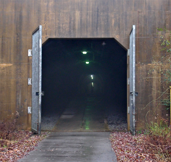
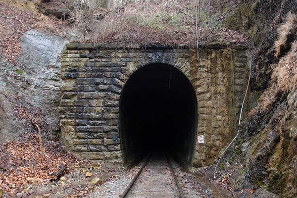
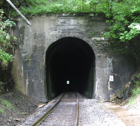
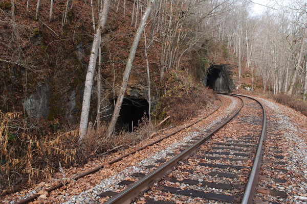
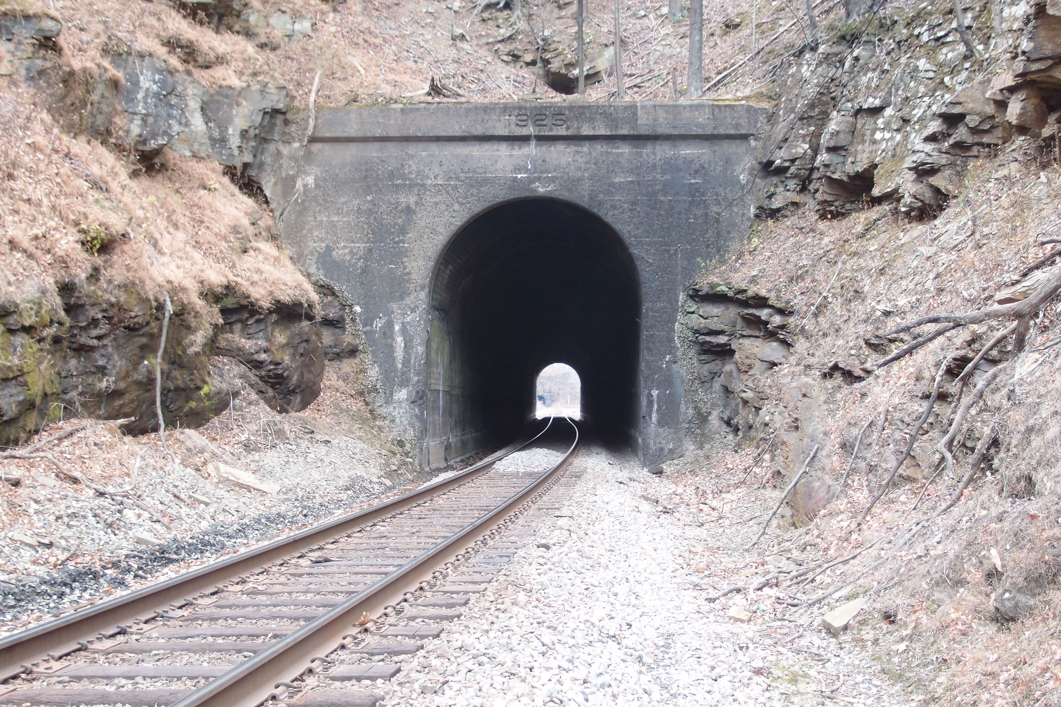
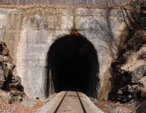
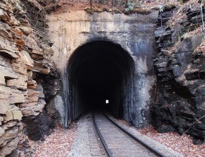
Kentucky truss bridge

This solidly built double-track 1925 Fort Pitt Bridge Works (Pittsburgh PA) structure spans the Cumberland River just west of CSX’s Loyall Yard.  The bridge, in three sections, all box trusses (for a total of around 410′ in length), is at 36.85093, -83.36837.  It’s on an active line that winds on into Pineville.  This view is looking more or less west.  To give you a sense of scale, that’s my buddy standing in the second section on the right hand side of the tracks.
OLYMPUS DIGITAL CAMERA

Harlan KY

This is a 1910 Louisville Bridge and Iron Company pony girder just off 421 going into Harlan from the south.  CSX now owns this former Louisville & Nashville bridge over Martin’s Fork River.  Beyond the bridge you can see the huge door that closes off this area in the event of flooding (which Harlan was very susceptible to)…it’s part of a 5,000′ long wall that protects the city from rising water.  The flooding used to be worse, before they cut the three large tunnels to divert the Clover Fork River to near Baxter (see the tunnels here).
OLYMPUS DIGITAL CAMERA

Two Kentucky bridges

These two open camelback truss bridges, made by “American Bridge Co. of New York U.S.A. 1910” (the plates are the same on both…they’ve survived for 104 years!) are located on a dead L&N line that came out of Cawood KY and joined a line that came from Three-Point KY and moved on to Harlen and, probably, Baxter.  The date is right to the line. I don’t know when this line went dead, but both these bridges have been converted to pedestrian use (people walked through the wet cement, scrawled their names and initials, but a date?  Not going to happen.) This was part of the Cumberland Valley extension of the L&N that, through interchanges and leasing, heads Lynch and beyond (“To infinity and beyond!“).

This one’s just outside Cawood at 36.78422, -83.23707, looking generally west.
OLYMPUS DIGITAL CAMERA


This is the date plate on the above bridge
OLYMPUS DIGITAL CAMERA


This bridge is west of the one above.  It’s at 36.81457, -83.28791.  It’s between Chevrolet and Grays Knob KY (looking NE)
OLYMPUS DIGITAL CAMERA

Bridge over Martins Fork (KY)

This is one of three deck girder bridges over Martins Fork in Harlan County KY between Chevrolet and Cawood.  They were constructed in 1928 by the   Bethlehem Steel Company in Bethlehem PA.  This line is active CSX, but I suspect the line was put in by the L&N.  There’s a spur line, now dead, just north of here at Lenarue that parallels (sort of) Hwy 990 up to the Mary Helen mines.
This particular bridge is just off Hwy 3001 over Martins Fork.  It’s about 280′ long.
OLYMPUS DIGITAL CAMERA

Rail Real Photo Postcards

These three are real photo postcards; that is, one-off postcards made by Kodak from negatives sent in by camera owners.  The photo of the N&W hopper and the two crew cars can be dated to between 1904 and 1918, as can the shot of the steam locomotive.  The one of the crane resetting a CC&O derailment is from the 1918-1930 period.  There is no other identifying information on any of these cards.  I think they’re fascinating and I snapped them up as soon as I saw them.
n&wcrewcars


n&wsteamloco


derailment

Reedy Creek Bridge

This is original to the line, as far as I can tell.  The date (1907) is right.  This two span concrete bridge for the CSX (formerly Clinchfield) over Reedy Creek is  just off Industry Drive in Kingsport, near the new roundabout on Netherland Inn Road. (There’s a new span that takes the line over Center Street as it intersects Netherland Inn Road.  I vaguely remember the old span, which was just a two-lane overpass.  There are remnants of the old concrete structure still in place up on the line.)
This span actually no longer carries the weight of the line, it’s been strongly reinforced.  It you go by this now, you’ll see the Greenbelt covered bridge going through the left span.

reedycreekbridge

For all you pons pontis-ophiles out there

Neat, closed-to-traffic, concrete arch bridge was made by Luten Bridge of Knoxville in 1918.  This goes over Puckett Creek at Stone Creek and used to connect St. Charles Road with what was then the highway between Pennington Gap and points north.  It’s very near the intersection of Highway 421 and St. Charles Road just north of Pennington Gap. Here it is (this is looking from the highway side).  A tip of the bald guy’s cap to Lee Stone for spotting this one.

OLYMPUS DIGITAL CAMERA


Here’s the identifying plate
OLYMPUS DIGITAL CAMERA

Old Interstate bridge

This gem of a McClintic-Marshall Company (Pittsburgh PA) 1922 deck girder is on the old Interstate line between Norton and Coeburn.  It’s original, since this line was constructed in 1923 or so.  It crosses an active N&S line and the Guest River.  Surprisingly, the rail on the bridge is dated 2011 and it seems to have had moderate use.  It centers at 36.94253, -82.58283 and it’s maybe 260′ long.

OLYMPUS DIGITAL CAMERA

#36 Brush Creek tunnel

I’ll be damned if I didn’t miss a tunnel in all that scouting along the CSX line between Erwin and Altepass.  My buddy called me a couple of days ago and said he’s spotted a tunnel on the topo that we hadn’t been to…it was on the Toe River, just west of Loafers Glory NC.  I went up on Google Earth and located it at 36.00598, -82.23743.  It’s in Goforth’s book at 163.11 miles south of Elkhorn City.  I’ve looked at that list a dozen times and completely missed this tunnel.  The tunnel is 304′ long on a curve and completely unfinished, except for some supporting concrete on the left of the south portal.  Strong stone there, for sure.  Here’s the south portal and the mile marker just before the south portal.

OLYMPUS DIGITAL CAMERA


OLYMPUS DIGITAL CAMERA

Highline tunnel, north portal

Here it is, the north portal of the Highline tunnel near Cawood KY at 36.78308, -83.24311.  It’s one of three tunnels between Cawood and Smith KY (where Hagan tunnel’s north portal is). This one is a little over 1,200′ and curved, so you can’t see the other end from here.   Note the lack of facing, indicating that the rock here is strong. The line is active.  And, as you see from the mile marker, 251 miles from somewhere.
OLYMPUS DIGITAL CAMERA


OLYMPUS DIGITAL CAMERA

Clover Branch tunnels

Go northeast on 38 from Harlan KY for just under a mile and you’ll see these tunnels.
OLYMPUS DIGITAL CAMERA

We didn’t know what to make of them, so, when I got back, I did a little research.  They’re an Army job.  Finished in 1992, these four tunnels divert the Clover Fork of the Cumberland River away from downtown Harlan, where there had been a history of flooding, into Martin’s Fork.  The tunnels here are at 36.85526, -83.31546.  The one the left carries the most water, normally.  The actual input portals are at 36.85125, -83.31086, about 2,000′ away to the northeast going under Ivy Hill.  The four tunnels minimize the possibility that one will get clogged up with debris in a flooding situation.  Those who canoe or kayak say that these tunnels are safe, with smooth bottoms and moderate flow.  The rock around the tunnels has been sprayed with concrete to stabilize it.  You never know what’ll turn up in Kentucky.


Center Street Bridge, Kingsport

I’ve bought a new negative/slide/print scanner.  It does pretty good for the price ($109)(it’s an SVP)(China).  While looking through some old color negatives, I came across this one that I’d taken maybe 25 years ago.  This bridge, which spans the fabled Reedy Creek (as in that legendary perfume “Reedy Creek Mist”) and the Greenbelt, was replaced by the City a couple of years ago.  I hope someone kept this.  The plaque is hard to read in this resolution and size, but here’s what’s on it: Federal Works Agency/Public Works Administration/John M. Carmody/Federal Works Administrator/Franklin D. Roosevelt/President of the United States/Center Street Bridge/1939.
Parlous times, those were.  Probably quite a few men were damn glad to get a chance to work on this bridge.

My beautiful picture

1917 underpass near Glade Spring

At this point, Highway 751 passes under the Norfolk-Southern line that comes out of Marion.  The concrete on this underpass is beginning to show its age.  Interestingly, there’s a wye at Glade Spring, just west of here.   We’re at 36.79238, -81.74222, with the main highway behind yr. hmbl. photographer.  The date “1917” is stamped into the concrete above the right underpass.

OLYMPUS DIGITAL CAMERA

#31 Sensabaugh tunnel

The plan today (9/1/13) was to head up to Sensabaugh Hollow, scramble (again) up the fill to the railbed and retake Sensabaugh and Click tunnels, which are within a half-mile of each other.  Now, we’d checked the radar and we had seen an area of rain moving in, but we figured it was at least thirty minutes or so away.  Wrong again.  Just after I finished taking the picture below, we heard thunder, turned around to look north and saw the storm moving in.  We looked at each other and said, almost in unison, “It’s a washout!”  We got back to the car just as heavy rain began.
Sensabaugh, by the way, is the first tunnel on the CSX line going north from Kingsport (this is a southerly view).  It gets its name from the small stream that runs down this hollow.
OLYMPUS DIGITAL CAMERA

Double tunnels near Cawood KY

The CSX line (former L&N)  going above these two underpasses is active.  It comes down from Harlan and heads into Hagan Tunnel.  The dating on the faces of the tunnels on this line is 1930.  Since the date on the culvert between these two tunnels is 1951, I suspect (and will readily accept correction) that these probably date to around that time, more than likely replacing a timber structure.  This is the former railroad underpass:

OLYMPUS DIGITAL CAMERA


This was a line that branched off a line through Cawood and came through here on the way to Three Point, where there were three drift (deep) coal mines.  Back when the railroad was here (it’s now County Road 1705), the depth of the ballast would have made the tunnel look less intimidating.  This is centered at 36.774076, -83.243284.

This is the auto underpass, just next to the above.  It’s at 36.773738, -83.243456.

OLYMPUS DIGITAL CAMERA


This would have been the vehicular access (Rt. 991) to Three Point.

Hagan Tunnel, North Portal

We had been meaning to get this portal for quite a while.  This is in Kentucky, near Sampson.  The portal has a 1930 date, clearly seen.  On my other post for Hagan Tunnel, I note that the line came through here in the late 20s.  This, then, may be an original portal facing, done when the road was completed (another tunnel on this line near here also has a 1930 date).  The tunnel comes out in Hagan VA, where there are two wyes (see the comment below…it’s a switchback).  The railroad was in the process of working on this tunnel.  Off to the right you can see the 750 kw generator.  This also an air compressor on site, to which the orange-ish lines coming off the horn things are attached to.  (edit here: the “horns” are there to allow the compressor to push fresh air into the tunnel when workers are present)

OLYMPUS DIGITAL CAMERA

Miller Yard Bridges

Miller Yard (or Miller’s Yard), northeast of Dungannon, used to be a happening place.  A little bit east of the main yard was once the junction where the Interstate line out of Coeburn (going down through Guest River Gorge) hooked into the Clinchfield line.  The old Interstate bridge over the Guest River is a McClintic-Marshall deck girder made in Pittsburgh in 1922.  This bridge is now the lower terminus of the Guest River Gorge Trail.
OLYMPUS DIGITAL CAMERA

The other bridge, which is nearly impossible to easily get a good picture of, is active and much older.  It’s a Pennsylvania Steel Company deck girder made in 1907 in Steelton PA.  I can explain why there’s not a better picture.  To get a view of the date plate on this bridge, I had to scramble down the abutment of the other bridge, then carefully make my way down the Guest River, stone by stone, to where I was under this bridge.  I could have gone back up and then carefully made my way down the abutment you see in the picture (on the other side of the river) to a place I could have taken a better picture.  Forget about it.

OLYMPUS DIGITAL CAMERA

1927 narrow underpass

This is on Roy Martin Road in Gray TN (36.410614, -82.458446).  This must have replaced an earlier timber supported Clinchfield pass over the road (the line came through here around 1908), but, in 1927, there still wasn’t enough traffic on this still relatively quiet road to justify two lanes.  Gray, btw, was once called Gray Station, since there was a train station located about where the Citi telemarketing building is now.  This is looking north.  Further on, this road descends through a virtual tunnel of trees.  It’s really pretty.  The road comes out at Bobby Hicks Highway, by the new Credit Union building.

1927overpassroymartinrd

Couple of railroad underpasses

 OLYMPUS DIGITAL CAMERA We’re just outside Bluefield WVA at 37.259336, -81.253291 (centered), looking
back at the highway through a 194′ railroad underpass. Not dated. This goes
under at least 9 railroad tracks
at the end of Bluefield yard.
 OLYMPUS DIGITAL CAMERA This one is on Depot Street (or Baptist Hollow Road) in Bluefield VA. It’s short
and not particularly distinguished,
but what interested me is the dating:
1890 – 1931. I’ve never seen this type of date marker before.
This is all N&S stuff, btw.

Elkhorn tunnel

This tunnel, referred to in early N&W documents as “Tunnel 377”, was first known as the Coaldale tunnel, but is now officially (as the sign on the lintel says) the Elkhorn tunnel.  Shown is the SE portal at 37.333022, -81.338904, about one mile as the crow flies, from the NW portal of the Coopers tunnel, across the Bluestone River.  The tunnel is on the Flat Top Extension, which opened up a way to the Ohio River for the N&W.  It was excavated between 1887-1888 and is 1.3 miles long.
OLYMPUS DIGITAL CAMERA


As you can tell by the comment below, this posting is pretty much just twaddle.  This is the Elkhorn Tunnel, but it’s Elkhorn Tunnel #2. The original tunnel was a single-track jobbie about 3,100′ long.  That line was electrified between about 1915 to just after WWII.  Wanting double tracks and seeing needs shift, N&W bored this tunnel, about 1.5 miles NW from Bramwell WV.  It was dedicated in 1950.
According to Buddy French (http://shinbrierwv.com/coaldale/return_to_coaldale_-_great_story_by_buddy_french), the old Elkhorn Tunnel, located at Coaldale, was abandoned and filled in after the new line was built.

I always appreciate comments and corrections, always!

Patterson Branch Tunnel, um, no, it’s Log Mountain tunnel

In the late 1800s, the L&N was mad to get to Middlesborough KY.  The town was going to be the “Birmingham of the South” because of the good quality iron ore that had been found in the area.  English investors came in and everything went swimmingly until 1890, when the town basically burned down.  In 1893, a financial crisis hit and it was pretty much all over for Middlesborough.  But, not quite.  The town rebounded eventually and is still a bustling city in a meteor crater.  Anyway, the L&N, out of Louisville, of course, had a line into Corbin and began to extend it down to Middlesborough, reaching the city about the time of the fire.  Along the way, the company blasted out two tunnels.  This is the one closest to Middlesborough.  Track is not active. (note the informative comments below)

OLYMPUS DIGITAL CAMERA

This is the south portal at 36.714330, -83.671929.  The tunnel is about 250′ long.

OLYMPUS DIGITAL CAMERA


This is the north portal, which carries a 1944 refurb date.