Cumberland Gap tunnel (the old one)

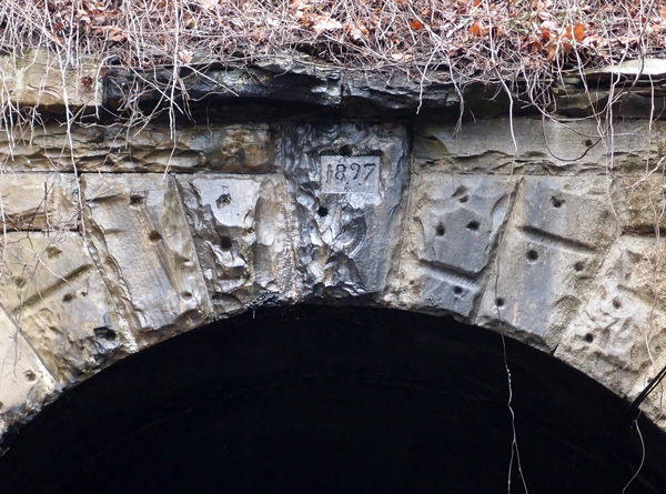
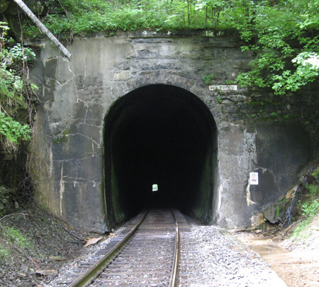
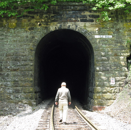
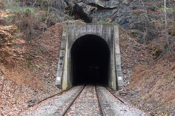
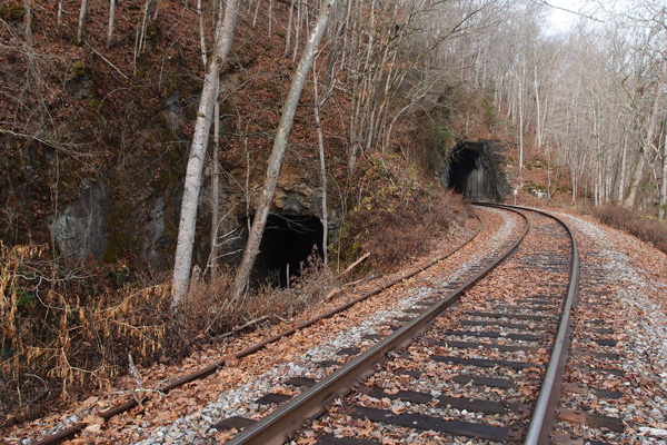
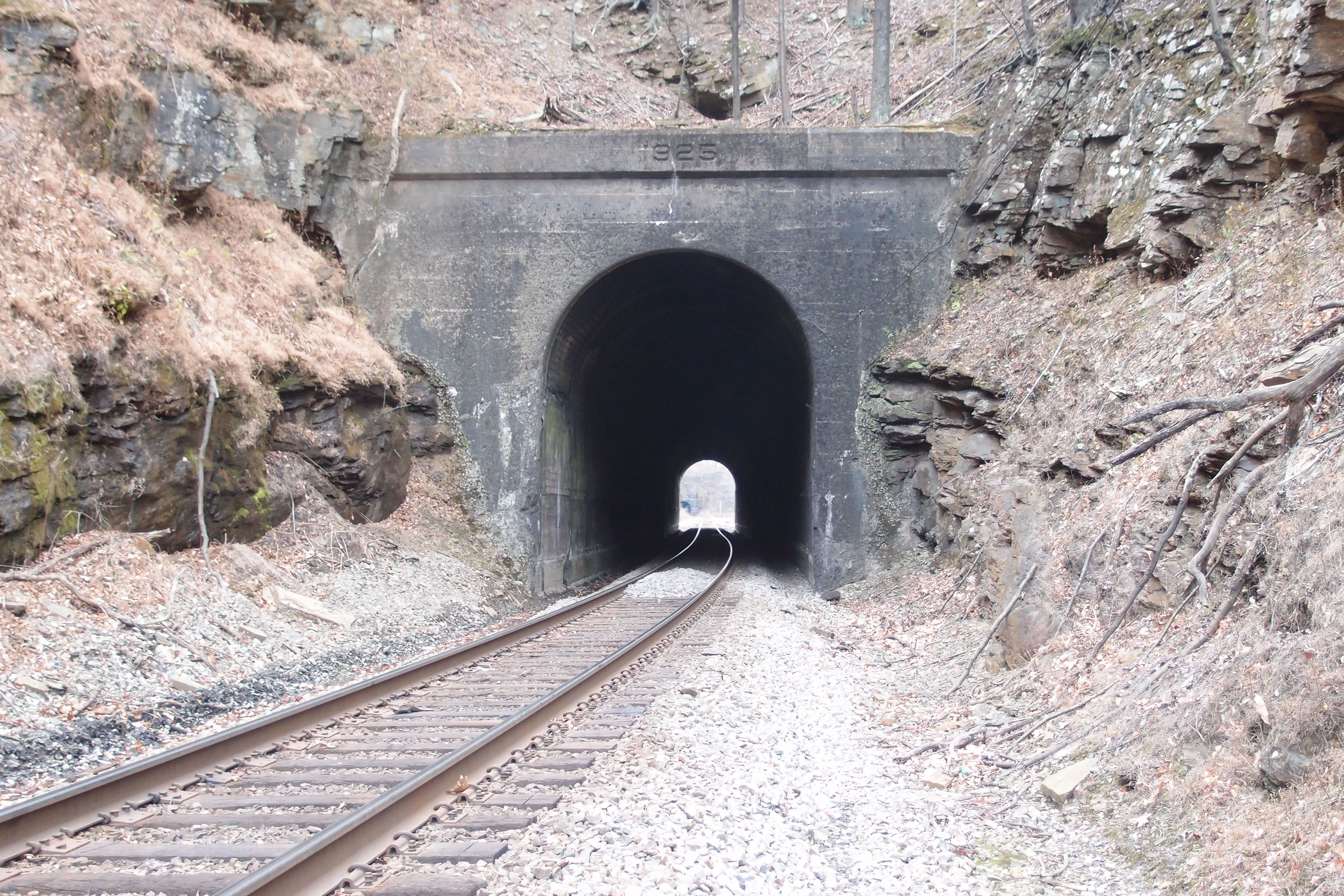
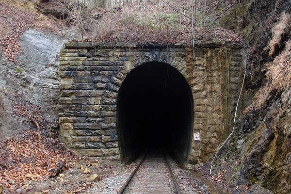
This is the last tunnel on the line coming out of Knoxville.  As I’ve mentioned before, the Knoxville Cumberland Gap Louisville railroad company blasted out this tunnel in 1888-1889, with a grade going up to the more or less center of the tunnel on both sides, so the cross-section of the mountain would reveal a tunnel that looks like an inverted “V”.  Smoke had a tendency to collect at the top and make breathing difficult for crews and passengers. Then, to add to the woes, the tunnel collapsed on July 4, 1894, and again in 1896.  Engineers didn’t like to go into the tunnel, so they’d push a string into the tunnel and have another locomotive pull it out from the other portal.  Passengers had to take a wagon ride through the gap.  This wasn’t a good situation.  When L&N gained control of the tunnel (KCGL had gone bust in 1892), they did a complete refurb ending in 1897, which is the date on this portal (this is mostly from “History of the Louisville & Nashville Railroad” by Maury Klein). It’s also the date that “Dracula” by Bram Stoker, was published.  When the tunnel was begun, the Buffalo Soldiers were active in the West, just 7 years after the gunfight at OK Corral.

OLYMPUS DIGITAL CAMERA


(I’m proud of this blog.  Someone came in and lifted a lot of the text above the picture.  The text ended up, with no credit, scrolled in purple (!) on another website.)
If you’d like to see a great video taken from a locomotive of a trip through this tunnel:
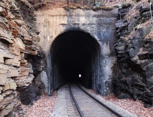
long and narrow


Here’s a closer look at the date on the lintel:

OLYMPUS DIGITAL CAMERA

Holbrook tunnel

The third tunnel between St. Paul and Coeburn is Holbrook.  It centers at 36.924873, -82.372080 and is about 1,600′  long.  A trestle begins 11′ or so inside the northwestern portal and extends 625′ over a valley.  It’s dated 1947, but, since the tunnel was blasted out around 1905, we know it’s a replacement for the original timber trestle (and it must have been some trestle!).  There are two more trestles before we get to Coeburn, both high and long.

holbrook

Greer tunnel

This is the last tunnel on what is now the mostly abandoned N&S line coming from Knoxville to Cumberland Gap.  This is Greer tunnel, close to a feature called “Greer Lake”  (not seeing a Greer Lake, folks) and New Tazewell.  This portal, the northwest, is at 36.423103, -83.591183.  The tunnel, soggy and drippy, seems to be about 350′ long.   The history of this railroad and the changes in its trackage provide interesting reading.
OLYMPUS DIGITAL CAMERA

Sycamore tunnel

We were faced with a dilemma.   We knew we didn’t want to cross the trestle coming out of Oakman tunnel over Norris Lake because it is a bare-bones trestle, with no provision for any foot traffic.  Although the line is, for all intents and purposes, dead, we were still leery of being on a rather exposed stretch of tracks.  So, we walked back to our vehicle and drove around to Lone Mountain marina and hiked in to Sycamore tunnel from there.  This north portal is at 36.378498, -83.562599.  The tunnel, which has a bend,  is around 740′ long.  The south portal looks much like this one and, after 260′ or so, heads out over another narrow trestle.

OLYMPUS DIGITAL CAMERA

Oakman tunnels #2

These are the trestles coming out of both Oakman tunnels at the northwestern portals.  On the left are the remnants of the original trestle over the Clinch River.  It was abandoned and later disassembled and hauled away by elves or something.  The sturdy bridge to the right, probably circa 1936 or so, carries the line from the newer tunnel.  We’ll hit Sycamore tunnel next, then the soggy Greer tunnel, near New Tazewell.
OLYMPUS DIGITAL CAMERA

Rift WVA

I thought I’d posted pix from this wye up in Rift WVA at 37.281159, -81.665041.  There are three trestles here: a through truss, a pony truss and a pony plate.  All take the line over the Clinch River.  The first picture is the through truss and the second shows the humor of the rail guys.  It’s hard to read the far junction sign, but it reads “‘Omega”.

rifttruss


riftjunction


The Oakman tunnels

In the late 1800s, the Powell’s Valley Railroad made ambitious plans to run a line from Knoxville to Cumberland Gap.  This was in the waning heyday of Middlesboro KY, just on the other side of the Gap (Middlesboro sits in a meteor crater, btw).  The L&N was already in Middlesboro and was looking to get through the Gap to extend their line southward.  When the Powell’s Valley Railroad became the Knoxville-Cumberland Gap-Louisville railroad, the L&N talked them into blasting a tunnel through the Gap.  On the way from Knoxville, though, the line had to cross the Clinch River at this location.  A tunnel was dug through the ridge and a bridge was built and all was well…until TVA began to construct Norris Dam, which was completed in 1936.  The Southern Railroad, which now owned the line,  realized that their trackage here was too close to the water line, so a new tunnel and a new bridge had to be constructed.  These two portals are at 36.363018, -83.550292. The new tunnel is about 330′ long.  There was an historic community called “Oakman” about a mile to the southwest of this tunnel.  It’s gone, but the tunnel isn’t.  That’s how it goes sometimes. We’ll take a look at the other side next.
OLYMPUS DIGITAL CAMERA

#44 The Loops: 3rd Washburn

We’re now a little over 191 miles from Elkhorn City.  We’re at the southernmost point of the first of The Loops, about a quarter mile past  Quinn Knob tunnel.   3rd Washburn is a curved tunnel, 915′ long.  This is the western portal at 35.839883, -82.037946.  The date on the lintel is 1913.  Snipes is next, but, as I said, we’re heading down to Norris Lake for an interesting series of tunnels (if you’re into tunnels).  We’ll get back here real soon.  The tunnels will still be here.

OLYMPUS DIGITAL CAMERA

#43 The Loops: Quinn Knob

As the CSX heads down the Blue Ridge, it makes the first Loop, curling around to come back to about 100′ away from the tangent that leads into it (but 132′ lower).  Coming out of 2nd Washburn, about 1/4 mile away to the south, lies Quinn Knob tunnel, 545′ long.  It carries a 1912 date on this south lintel at 35.841637, -82.041630.  It’s on a slight bend, leading to 3rd Washburn, which we’ll get to shortly.  Then we’ll take a break and gaze at four tunnels down on Norris Lake.  Ever hear of the Knoxville, Cumberland Gap & Louisville Railroad?  It was involved in the breaching of Cumberland Gap for the mighty steel rails.  More later.

OLYMPUS DIGITAL CAMERA

Diversion: Kent Junction

Kent Junction is centered at 36.921466, -82.728876, northeast of Appalachia.  I don’t know why I like it so much…it’s just sort of a tidy triangle of trackage (heh, alliteration) out in the country. It was originally laid down by the Interstate Railroad as part of its trackage to Cane Patch and to Dorchester.  You can get a good look at it on Google Earth.  That N&S loco isn’t going anywhere.  It was just sitting there, hissing occasionally.  This was in February, 2012.
kentjunction

#40 The Loops: Upper Bridal tunnel

About a mile or so southwest of  Upper Pine Ridge tunnel, lies Upper Bridal tunnel.  It’s a curved tunnel, which mimics the curve of the Blue Ridge Parkway to the northwest of it.  The tunnel is fairly easy to get to, if you know what you’re doing.  This weathered southwest portal is at 35.855180, -82.035674.  The tunnel is 927′ long.  Around 1905 or so, nine workers were killed here when someone accidentally ignited 15 cases (100 pounds each) of dynamite (according to Ashton Chapman in the Charlotte Observer 8/23/53).  Seven workers were killed on the same day, in another area, when a cut they were working on collapsed.

OLYMPUS DIGITAL CAMERA

#38 The Loops: Blue Ridge tunnel

This is the east portal of Blue Ridge tunnel (35.883516, -82.018091), also noted on maps as Ridge tunnel.  It’s 1,865′ long and goes under the Blue Ridge Parkway. The far end up there is 187.28 miles from Elkhorn City KY. After Vance, this is the first tunnel heading down the eastern slope of the Blue Ridge mountain.
ridgetunnel

2nd Cawood tunnel

This tunnel, fairly short, is south of the Cawood KY tunnel on Bob’s Creek at 36.766159, -83.242214 (this is the north portal. The south portal is unfinished).  A man who lives near this tunnel, after checking our religious credentials (we lied)(sorry), confirmed that the 1929 date on the tunnel is consistent with the building of this line.  He also regaled us with stories of at least four people who died on the railroad for various reasons (drunk, stupid).  That stuff rolls off our backs like duck water.

Tunnel near Cawood KY

This is the southerly portal of a long, 1/4 mile or so, tunnel on the CSX near Cawood KY.  Anecdotal evidence (I’m still doing research) indicates that this line was laid down in the late 20s, but the date on this portal, if there ever was one, has been eroded away.  This portal is at 36.77949,  -83.24325.  A picture of this on Google Earth is titled as being near “Bob’s Creek”.  Not my creek, no sir.

Crummies Creek tunnel

Between 1924 and 1931, a narrow-gauge railroad hauled coal from the Crummies Creek mines to a prep plant on the other side of the mountain on Cemetery Road near Crummies, KY*.  This portal, probably dynamited and then filled in, is near 36.78559, -83.21749.  Good luck trying to find it on Google Earth.  We nearly missed it ourselves.  When I took this picture, I was standing on top of the fill looking into the tunnel right at the top. I could feel cool air blowing out, so the tunnel’s not completely filled in.
On the prep plant side, there were several L&N lines that used a double-track loader.   The tracks are gone now.


*The Kentucky place name list tells me that a “crummy” or “crummie” refers to an animal that has crooked horns.

Appalachia VA and Limestone TN train depots

For the last few  months, I’ve been recording the train depots (if available) and the post offices of many of the small towns we drift through on any given Sunday.  Both the depots and the smaller post offices are slowly going away; the former from neglect, the latter through an excess of penury on the part of the USPS.  Here are two standard issue, well-built train depots that have fallen into ungraceful disuse.
First, here’s the Appalachia depot, on the L&N.


And this is Limestone’s depot on the N&S.  It was, at one time, a stylish building.  No longer.

Natural Tunnel VA

You know about Natural Tunnel, right?  If not, here’s the Wiki.  And here’s a picture of same, complete with the N&S track that’s been there for over a hundred years:


But, wait! There’s more! Because, in railroad design thinking, it’s usually better, more costly, but better to ram through than go around, there’s another tunnel just a little bit south of the main, naturally formed (of course) one.  Here ’tis (this is the northern portal…(kinda looks like they just sawed through the rock, no?):

Cooper tunnel

N&W always called the tunnel “Cooper”, but it’s located at Coopers, a small community that was once a busy junction on the N&W.  The company store is still intact, as are several other structures.  People still live here.  Coming out of this tunnel and flying over both the Bluestone River and County Highway 120 is a massive deck truss trestle.  Between 1919 and the early 50s, this line was operated by electricity.  The tunnel, just a few miles from Bramwell WVA, is centered at 37.320506, -82.326452 and is about 758′ or so (measured on Google Earth).  The date on this NW portal is 1902.  The tunnel goes through Laurel Ridge.

Pounding Mill tunnel #2

This is Pounding Mill tunnel #2, looking easterly.  It’s centered at 37.078653, -81.738603 and is about 377′ long.  A straight line distance from tunnel #1 is a little over a mile, but probably along the line of 2 miles if you walked the track, which we didn’t.  And we had a very hard time finding this tunnel and #3, since Google Earth, of which we are not worthy, made a teensy error, labeling Estates Street as Ash Street and we were totally lost.  Lee was hungry, it was nearing noon, so he suggested we give it up and head over to a nearby Wendy’s so he could get one of their baked potatoes.  I rarely eat potatoes, so I stayed outside, propped up against the car, looking at the topo map to see if there were any other way to get down to where those tunnels are.  An SUV pulled up.  The driver, a man, leaned over his passenger, a women, and asked, “What are you looking for?  I might be able to help you.”  I took the topo over and was pointing out where we needed to go to both the man and, as it turned out, his wife.  She took one look at the map and said, “That’s where my parents live.”  As I batted away the angels singing around my head, I explained that we needed to find Ash Street.  The man said that they’d changed the name of it to Estates Street.  Problem solved.  He called ahead, got permission for us to cross his father-in-law’s land to get to the railroad and the tunnels.  When Lee came out of Wendy’s with his food, I told him what was going on and he just laughed and shook his head. “Who would believe it!”

So, here’s tunnel #2.  It probably looks pretty much as it did 120 or so years ago.

Pounding Mill tunnel #1

We’re about halfway between Cedar Bluff and Claypool Hill in Tazewell County VA.  This is on an N&S line from Bluefield to Norton.  It’s the first of three.  It’s centered at 37.078360, -81.746409 and is about 545′ long.  This line came through between 1887 and 1890.  We’re heading up to the UrCoal region: Pocahontas, but we’ve got a couple more tunnels to check out.

Dry Fork tunnel #1

This is Dry Fork tunnel #1 (37.234365, -81.639281), about 470′ or so.  This is looking north from the trestle over the Rift-Berwind Road and Dry Fork River in West Virginia.  Bridge facing date is 1912, with a 1911 date on the trestle abutment.  Pending further research, I’d say the line here dates to the late 1800s, when the coal mines began to open up.  Our general theory with the lines in the area is that they blasted out the tunnels, leaving them unfinished if they were stable and ran the line over timber trestles until either the trains got heavier or the timber began to deteriorate, then they switched to the current configurations.  It’s a theory.

Dry Fork tunnel #2

Dry Fork tunnel #2, centered at 37.222078, -81.633671.  It’s about 478′ long.  1912 date.  Thanks go to Lee Stone for the picture…I was still fussing with my camera after taking the dusty slide…plus, I wasn’t interested in climbing a long fill again.  Wonder why?  As of this date, it doesn’t bother me at all.

Dry Fork tunnel #3

This is a long one.  It’s 4,688′ or so and centered at 37.152524, -81.693367, near Bandy VA.  Interesting design on this portal.  Since I’d just made a production of sliding on my belly down the 30′ or so embankment coming up here, I wasn’t in the mood to trudge over to the other portal to check it.  You can,  if you want to.

Meadowview VA train station

Yeah, it’s not a tunnel, but I’ve gotten interested in documenting the remaining train stations in our area.  Some are pretty tarted up and some are gone.  Some have character.
This one, which appears to be on the road to renovation, is in Meadowview VA.  It’s pretty much standard issue train station.
The railroad came to Meadowview around 1856 and kept the community prosperous until the 1950s.  Meadowview, also known as Meadow View, is near Whitetop Mountain.

Dry Fork tunnel #4

We’re just off Hwy. 627 about a mile south (as el cuervo flies) of Bandy VA.  This tunnel is centered at 37.128412, -81.699718.  It appears to be about 501′ long.  There’s a trestle  a little bit past this northern portal that goes over 627, but, since I lost my notes on this journey, I don’t recall the date on the trestle.  Btw, I’ve replaced both the voice recorder and the eTrex with newer models. I tried them out last Sunday as we explored the old town of Bulls Gap…first railroad there was built by slave labor in 1857.  I’ll be posting it to www.unclebobstravels.com soon.

Dry Fork #5

We started in Cedar Bluff VA, working our way up the N&S line toward Rift WV.  There are five tunnels along the way.  It was a hot day.  I ended up taking a belly slide down the shaley embankment off a rail line (I was nearly to the top of the 35′ embankment when the loose dirt crumbled away from my foot and down I went, clutching a small tree that I had grabbed, hoping for a little braking, but I got breaking) and getting a fair amount of scratches (two on the lens of my Nikon, prompting my buddy to remind me about, you know, a skylight filter to protect the lens…).  Then, to top if off,  a few tunnels on, I absent mindedly left my Olympus voice recorder and my eTrex on the trunk of my car and then drove away.  God knows where they are.  But, I’ve got replacements ordered.  Paraphrasing a saying by my boss, “If you’re going to be stupid, you’ll have to pay.”

This is Dry Fork tunnel #5, centered at 37.109438, -81.723611.  This is looking more or less south. By the Google Earth ruler, it appears to be about 790′ long.  1912 date, as you can see.  This line could be far older than this date, since N&W could have done a full refurb of the line in 1911-1912 (there are these dates firmly on trestles and tunnels on this line), facing the tunnels and replacing old timber trestles.  If further research shows this is true, I’ll update this.