
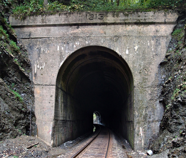
#32 Holston tunnel
If you’d been hanging out around this area in, say, 1777, you would have seen a fort down near the river, at a location that’s probably been obliterated by Tennessee Eastman or the plant that preceded it. That would have been Fort Patrick Henry (nowhere near the dam that carries the name). However, the tunnel wouldn’t have been here, since it was completed in 1913 or so. There are just three more tunnels in Tennessee before the rail line heads into the Appalachian Mountains (and that’s ap-UH-latch-ian, not ap-UH-lace-ian) (’round here). This tunnel is 154′ long. First is the western portal, then a look back at the eastern portal. A bridge here (which can be clearly seen on Google Earth) overlooks the old Kingsport waterworks and the never-completed 3-C railbed. Over the river and on to Colonial Heights.


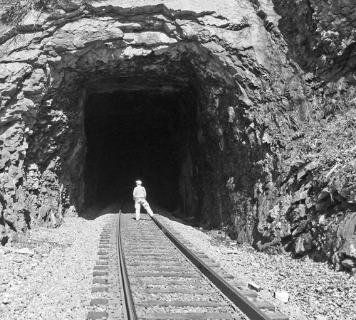
Sandy Ridge tunnel (the other one) – north portal
Finally! Thanks to diligent map work by my hiking buddy, a way was found to get to this northern portal of the other Sandy Ridge tunnel. It wasn’t easy. It was a bumpy drive down a long graveled road, across a strip mine, then down to the valley floor. After that, there was about 100′ to drop from the road to the last ledge before getting to the rail bed (the rails are long gone), then maybe 30′ down hanging from saplings and stretching to reach a foothold…from which I slipped and got my butt all muddy and wet (drove home sitting on a sheet of plastic…not the first time, either). Then, there was a slog through mud and running water to get just close enough to the portal to take the picture below. Not shown is the cataract coming down the right-hand side of the mountain…lots and lots of water. 1958 is the date on the lintel. Oh, and the climb back up the rock cut was even more fun. But I got the picture. Enjoy. Later note: I went back to near the tunnel entrance (I wasn’t even going to get down into that cut again) to do a proper GPS reading (my Garmin had, for some unknown reason, reset to a weird map datum the last time). Here it is: 37.037311, -82.189956. Going on back down the road, we found a place where a side road joins the railbed, now a rather dicey road of its own. The second picture is looking back toward the tunnel from the intersection. You would have problems walking in to the tunnel from here because of the large growths of wild roses and the average annoying briars. Back behind me, the road continues for maybe a half mile or so and ends at a strip mine. 


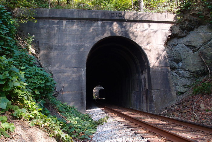
Whitesburg KY tunnel
There used to be an L&N rail line through Whitesburg KY. It’s gone now (the rails were pulled up in the late 80s), but this one tunnel and several deck girder bridges (constructed in 1912) remain. This unnamed tunnel (at 37.114941, -82.812306, more or less…couldn’t get an exact reading, since the tunnel cut is too narrow to allow a GPS reading and it’s difficult to see where the west portal is on Google Earth) is east of Whitesburg, near the city water works, through a ridge called “Tunnel Hill”. All the rails are gone and the tunnel is muddy as the Maytown tunnel is. It’s also short, maybe 150′ max. The first picture (say hello to Ranger, who manages to get in nearly every picture), is of the western portal (it’s unfinished, as is the eastern portal) and the next picture is looking out towards the east. It was just too wet to get through to the portal itself. The railbed from this tunnel on into Whitesburg (a neat little town) has been converted into a greenbelt. Judging by the rivet patterns on the bridges, the trains must have carried a fair amount of coal out of this area. (tip of the hat to Patty Hawkins and Lina Tidal of the Harry M. Caudill Library in Whitesburg for some of this information)


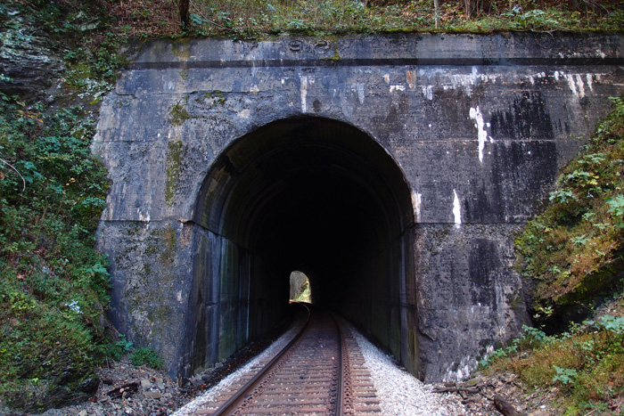
#31 Sensabaugh tunnel
Located through Sensabaugh Ridge at 36.577409, -82.625001, this bendy little (348′) tunnel is about a half mile south of Click tunnel, on the other side of Sensabaugh Valley, just a hop, skip and a jump from Beartown. We’re almost 89 miles from Elkhorn City. This view is looking south. I found a really nice piece of quartz near here, but I didn’t keep it. “Oh, joy, another piece of quartz.”
#30 Click tunnel (now in color)
Early in the process of laying out the route of the railroad, engineers had to determine where to build trestles and where to fill in to keep the track on a steady grade. When they came to the valley carved between Click Ridge and Sensabaugh Ridge, they opted to fill. They built a concrete underpass over Sensabaugh Hollow Road and Sensabaugh Branch (it runs through the underpass). Then, using the rock hewn out of the ridges for Click and Sensabaugh tunnels, they fashioned a 30′ or so high fill to keep the trackage at roughly 1300′ above sea level. The fill spans the distance from Click tunnel and Sensabaugh tunnel (coming up next). Coming out of Virginia into Hawkins County, you hit Click tunnel at 88.2 miles from Elkhorn City at 36.584876, -82.630481. The tunnel is 608′ long and apparently has the original facing set in 1913. There are stories about the road tunnel below the track being haunted, but, from what I hear, the locals think that’s hooey. This picture was taken looking northward, with Sensabaugh tunnel to my back.


#29 Clinch Mountain tunnel (now in color)
Clinch Mountain tunnel, in Scott County VA, at 36.637520, -82.735412 (center top of tunnel), is 4,135′ long. The date on the lintel is 1909. If you have hawk-keen eyes, you might just be able to see the tiny speck of white near the bottom of the tunnel opening…that’s the other end. It’s unfaced and just across Highway 23 from the Vulcan quarry in Speers Ferry, over a girder plate trestle. The next picture is back on the Kermit side of the tunnel, just off to the right. These are the ruins of a factory that was extant here in the early years of the last century. It mined sand from up on the Clinch Mountain, processed it, and shipped it Pittsburgh Glass. Odd to find that here…maybe it was super duper sand, or something. Remnants of the rail siding are still visible (not in the picture)(sidings aren’t particularly interesting).
As of October, 2013, the ruins of the factory are still much the same, but heavily overgrown. And, just as the last time, as I was taking this picture series (I’m just posting one), a CSX mixed-unit train came rolling through, generating enough wind in the cut to nearly take my cap off.

Here’s the north portal of Clinch Mountain tunnel:


#28 Speers Ferry tunnel
This tunnel is just west of Gate City VA at 36,647391, -82.744457. It’s 1,116′ feet long and has an odd-looking south portal, kind of skewed. Just back toward the highway from the tunnel is a quarry that you shouldn’t mess with, but is really an interesting place. With this tunnel, we’re nearing the Tennessee line. Up next, the 4,135′ Clinch Mountain tunnel, with an associated surprise.

Craigan Tunnel, St. Paul
Backing up a little bit to St. Paul VA, this is Craigan Tunnel (you can’t see the sign on the right side of the portal very well, but it states the tunnel name as “Creagan”) at 36.902711, -82.328600. The tunnel is about 900′ or so long. The date on the tunnel lintel is 1905. It was part of the Interstate line then, now it’s a N&S property. There was a huge fire in this tunnel in September of 1903 that required the St. Paul fire department, along with others, to build dams at either portal of the tunnel and pump it full of water. We started to walk through this tunnel, but decided not to. Good plan, that. Just as we climbed over the tunnel, a N&S double locomotive coal train came rolling through. 

#27 Bald Knob tunnel
We’re at the 78 mile marker (as you can see) now, at the natural portal of Bald Knob tunnel. The tunnel centers at 36.6666080, -82.750432 at about 1400′ elevation. It’s 453′ long and is about 1900′ southwest of Clinchport tunnel. While the former Clinchfield line bored through Bald Knob, the N&S (old Southern) ran their line closer to the Clinch River and avoided having to tunnel. I speculate that the unusual configuration of the rock, the near vertical face on the left) around the tunnel entrance precluded finishing it off with concrete. This is looking roughly south.

#26 Clinchport tunnel
We’re a little more than 77.5 miles south of Elkhorn City at Clinchport tunnel, actually near Boulder VA. The railroad here crosses SR 644 on a 1929 overpass (shown). Tunnel is at 36.671713, -82.745216 and is 637′ long. The first picture is looking south and the second picture is looking north with the lintel of the tunnel clearly showing the 1913 date. This was two years before the Clinchfield Railroad was officially completed. 


Swede tunnel (the real Swede tunnel)
My buddy always suspected that this was Swede tunnel (also called Beverly tunnel, according to Ed Wolfe in his book on the Interstate Railroad), located at 36.919845, -82.449835 on the Guest River Gorge Trail. I thought that Swede was the tunnel located in Coeburn (see that post), but, thanks to a comment from a viewer, I was corrected. I think this tunnel, the only one on the Guest River Gorge Trail, is about 200′ long. This is looking down the trail.

#24 and #25: The Twins
Located in Scott County VA, where the Clinch River makes a wide bend, these two tunnels bypass it by cutting through two close ridges. The North Twin (308′) is 71.26 miles south of Elkhorn City (quickly vanishing in the distance, well over the horizon, lost in Kentucky). The South Twin is just a few feet beyond the North. If you were standing between them, you’d be at 36.709679, -82.646909 and an elevation of 1343′. South Twin is just 236′, a mere slip of a tunnel. The first picture is the south portal of South Twin, looking north to the North Twin. The second picture is the north portal of North Twin, looking south to the north portal of South Twin. They’re both dated 1912.
#23 Starnes tunnel
Here we are a little over 70 miles south of Elkhorn City at Starnes tunnel, 517′ portal to portal. This is the south portal, 1911 date, looking north. Again, it’s a horseshoe cross section. The next picture is from inside the tunnel looking north to what is known as the 3rd Clinch River bridge, a 372′ through rivet truss (according to James Goforth). Calvin Sneed tells that the community near here, Starnes Slant, got the name when the crews were laying the railbed around a curve and kept fighting landslides, so the “slanted” the hillside to provide stability. Hence, Starnes Slant.

#22 Townes tunnel
Heading south, we’ve gone from Shannon tunnel in Russell County past the Guest River Gorge, past the old Miller Yard (it was quite a place in its day), to Townes tunnel in Scott County. It’s 1,098′ long. It’s at 36.851101, -82.436563. This view looks northerly, toward Miller Yard. This is an unusual horseshoe shaped tunnel, but the shape is related to the stress lines along the line of the tunnel. There was a train collision in this tunnel back in the day. It’s said you can still see the scars of the wreck inside the tunnel. I didn’t check, sorry. Starnes is next, then The Twins.

#21 Shannon tunnel
We’re now 47.6 miles from Elkhorn City, between St. Paul and Carfax VA in Russell County at 36.890949, -82.354993. The first picture is the horseshoe-shaped EC side portal of Shannon tunnel, 820′ in length, cutting through a ridge in an oxbow of the Clinch River. The horseshoe cross-section is deliberate, required, research tells me, by ground conditions in the area. This tunnel is not dated, but there is an impolite reference to CSX spraypainted on the lintel. The next picture is of the south (actually west) portal of the tunnel taken from the 300′ or so trestle that takes the CSX over the Clinch River on to Townes tunnel.


May Town tunnel
Here’s May Town tunnel. This northern portal is located at 36.936982, -82.465540 in Coeburn VA. It was constructed in 1922 as the Interstate Railroad ran a line up from Miller Yard through Guest River Gorge to Coeburn and points beyond. It went out of service in the ’60s and all the trackage has been removed. This tunnel is around 639′ long and muddy. We wore waders to get through it.
Btw, the Guest River Gorge trail is a great hike and there’s even one small tunnel on the way (Swede tunnel). It’s not far down the trail, but it’s a little over 5 miles to the Clinch River from the trailhead, it’s a long, long 5 miles back up. Each mile is marked with a sign and, as you’re coming back up, the signs seem to get farther and farther apart. We’ve done it on bikes and on foot. Bikes are recommended, believe me. Or a helicopter.

#19 Martin tunnel
This is the Elkhorn City portal of the Martin tunnel on the CSX…29.87 miles from Elkhorn City. The tunnel, at 37.041013, -82.308243, is 387′ long and, as you can see takes a turn to the right before opening out very near a community called Wakenva. The story is that this town was established by a coal company that had interests in West Virginia, Kentucky and Virginia. I don’t know how you get “West Virginia” from “Wa”, but that’s just me. The date over the portal is 1920.


Hagan tunnel (L&N)
This is the Hagan tunnel southern portal about 10 miles west of Pennington Gap at 36.706559, -83.288597 in Lee County VA. The tunnel, over 6,000′ long, runs from Hagan through Cumberland Mountain to Chevrolet KY, originally as part of L&N’s Cumberland Division. The tunnel was constructed in the late 1920s. There is also a single reference to another tunnel here at Hagan breaching the mountain higher up in a private or community effort back around the turn of the 20th century. It was used by wagons for commerce between the states (we couldn’t find it).
This place is also interesting in that there a switchback near this portal. The CSX train comes over the top of the tunnel entrance going in a westerly direction, moves off to the first switchback, then backs down to the other one, which allows it to head into the tunnel going more or less northward. All very complicated and a headache, I’ve read, for CSX, but since this is a lightly used, low speed line, they feel the cost of clearing all this up would not be profitable. It takes about an hour for the train we observed to make the complete transition. This was (I’m guessing) a 90-car unit. At that length, it was completely in the tunnel before it came out the other side (math – coal car: about 50′ or so and the two engines about 75′ each…making the train about .8 mile in length).


#18 Buffalo tunnel
Well, here we are at Buffalo tunnel, 26 miles south of Elkhorn City. The tunnel bores 352′ through a ridge where the railroad, which has been heading in generally easterly direction for a few miles, kinks sharply (for a railroad) to the south. We’re by the McClure river, a bit north of Nora, in Dickenson County. Decimal coordinates: 37.080040, -82.351309.

#17 Caney tunnel

Finished up in 1916, this is Caney tunnel, right at McClure VA in Dickenson County. It’s 412′ long, with a curve. Coordinates are 37.102793, -82.377871. Clean little tunnel..some exterior erosion, though. Figures, after nearly 100 years.
#16 Pettit tunnel
This is Pettit tunnel, just south of Clinchco and Squirrel Camp tunnel (so named, it’s said, because squirrel was about all the tunneling crew had to eat while they worked there). It sports a 1928 dating. Nice, sensible tunnel, 379′ long at 37.133940, -82.369548, just off Highway 63 (revisited). This was one of those “Well, here it is. Take a picture. Okay, what’s next?”. Next is Caney Fork tunnel, that’s what. Squirrel’s actually pretty good, btw. Mom used to make a killer fried squirrel with gravy. 

#14 Short Branch tunnel

This is Short Branch tunnel, just south of Reinhart. It’s located by the McClure River (I think that Short Branch is a creek somewhere in the area) and is 913′ long at 37.152285, -82.372719. The reface date on the portal is 1930. This is looking toward Elkhorn City and that’s me heading up to take a look into the tunnel.
The Tunnel With No Name
This is Rockhouse Creek tunnel (see below: locals called it “Love’s Branch tunnel”). It’s rudimentarily faced off, both portals, and located near Democrat KY at 37 13′ 45″ N, 82 48′ 55″ W on County road 1048, just off Love’s Creek. The tunnel is maybe 400′ long, with a curve to the east. I don’t know what purpose was served by the two horn-like things on the north portal (see comment by Jon Hirsch).


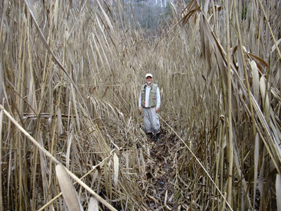
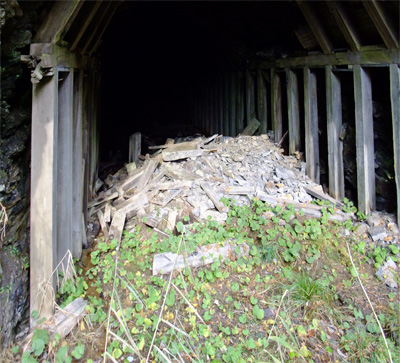
Pine Mountain tunnel, Part Two
We felt we really hadn’t made enough effort to document the eastern portal of Pine Mountain tunnel. My buddy acquired two sets of waders. And we needed them. The distance is short, but the way was uncomfortable in a number of ways. There were some sort of reeds that were dead, but towered well over our heads. See the picture of Lee (my hiking buddy) as scale.
There were also briars, cold water as deep as a couple of feet, with mud a little deeper…oh, and downed trees across the way. Not complaining, you understand, because seeing the portal was informative. James Goforth in “Building the Clinchfield” (ISBN 1-57072-191-9) says that Pine Mountain is located in “a highly disturbed fault area”. When I looked into the portal (on left), I saw what 53 years of neglect has produced: the roof of the tunnel is falling in. With a strong light, Lee was able to see more rockfalls further down.
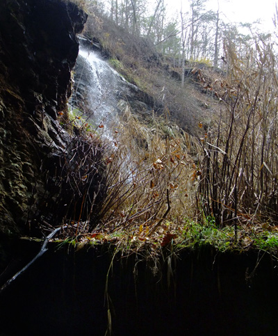
We also saw where all the water was coming from. The water is blocked from coming into the tunnel by a 4′ or so high cinder block wall just at the portal entrance.
After we sloshed and squished out to the car, we went over to Jenkins to access the western portal, but came to a locked gate. We decided that we’d had enough mud for this day and promised to come back later. However, I did take a shot of the abutment of a railroad bridge that apparently crossed an existing road as the line went on down into Jenkins.

#13 Reinhart tunnel
Here it is, Reinhart tunnel, 617′ long and with a 1924 refacing. It’s just across a trestle over Hwy 63 from Perkins tunnel. It centers at 37.157979, -82.372536. When I checked this tunnel out on Google Earth, I noticed that there’s an obvious track of the tunnel in the overburden. That was the first time I’d noticed that, but it happens with nearly all tunnels, unless the overburden is quite thick.

#12 Perkins tunnel
Here we are at Perkins tunnel and, as you can see, we’re 18 miles from Elkhorn City. The tunnel is 496′ long and was refaced in 1917…the date’s clear, but I went for the scenic shot, so you really can’t see it in this picture (but you do get to see the neat mile marker). This tunnel is at 37.161187, -82.370361, about .5 mile west of Clinchco.


#15 Squirrel Camp tunnel
Since I mentioned Squirrel Camp tunnel (668′), I’m posting it. It’s close to Sykes Mill tunnel, anyway…near Clinchco on the McClure River. 1929 is the refurb date. When we got to this tunnel, we realized that we didn’t know when the next train could be due…they were running at about a half hour apart, we thought. We didn’t want to be inside the tunnel when a train came through, so my hiking buddy, ever the optimist, suggested we just circumvent the tunnel by going around it on the river side. He even thought he saw a trail down there. About a hundred feet in, we realized there wasn’t even a trail down there, but we decided to push ahead. It was probably a little under a mile around to the other side, through dense undergrowth, bushes, small trees, large trees, damp glop and other lovely stuff. I managed to crack the view screen on my camera ($100 to repair, fyi). But we made it and stood on the other side huffing and puffing and then it dawned on us that we hadn’t heard a train go through. And didn’t see another the rest of our time there.

Pine Mountain tunnel
This is the Virginia (eastern) portal of Pine Mountain tunnel, blasted out in 1947 and sealed up, at least from the Kentucky side, in 1958. It’s just off Highway 667 above Almira, if you’re coming out of Pound. The access is at the “Red Fox Trail” sign, but don’t expect an easy way in. The railbed is heavily overgrown with high marsh grass and there was a lot of marshy goop around. We leaped, gazelle-like, across a creek and climbed up to the top of the cut and pushed our way through trees, some briars, and other of Nature’s finest obstacles, to where we could get a fairly clear view of the portal. You actually can’t see it in either of these pictures, but on that light-colored band across the top of the portal is written “1947 PINE MOUNTAIN TUNNEL’.
The Chesapeake and Ohio railroad created this tunnel in order to open up a vast (300 million tons!) coal field just east of Pound VA. A big thank you to Chris Balthis for providing me some rich research material on this nearly forgotten tunnel.


