“The Clinchfield Route”

nolichfront

nolichback

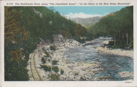
This is looking south at approx. 36.0720N, 82.3987W.

The card was printed by Curt Teich in Chicago.  It’s one of the “C” series of post cards issued between 1905 and 1926.  The Curt Teich records for this period are scanty and this number isn’t listed anywhere that I can find.  Nicely printed, though, and hand colored at the factory before the separations were shot for the print run.

Conneaut O.

nycf

nycb

Conneaut OH is up on Lake Erie and in 1914, when this card was mailed, it had at least five railroads passing through it.  One was an electric commuter line, others were freight.

I bought this card as soon as I saw it.  It’s a typical Curt Teich day-to-night scene, but it’s nicely composed.  Other than that, it just evokes a time long gone.

Plattsburgh Barracks has an interesting history, check it out here.

Nolichucky River Bridge (Unaka Springs)

bridgefacebridgeback

I think this card is from the early 20s.  I don’t know what company actually printed it (“published by Erwin Drug” just means that the drug store commissioned the postcard run).  American News Company of Boston farmed out a lot of the black-and-white work to Curt Teich in Chicago.  The inventory number does seem to indicate ANC.  However, I’m still working on this.  I have several cards in my collection that have the same back design and one seems to indicate it was done by Asheville Post Card Company.
Another maybe: this design often is shown with “COMMERCIALCHROME” AND “OCTOCHROME” in place of the “BLACK AND WHITE” wording.  It gets complicated.
Whatever.  This bridge is a 1907 replacement for an earlier timber structure and is, according to Goforth, is a TPG, a through plate girder style built on stone piers (possible: Goforth had access to original construction data and may have been using the TPG abbreviation to mean “timber plate girder”). It’s 864′ long.  This view is looking back toward Erwin. Note the steps up to the railroad grade.
This is the same bridge in 2014 (36 05 56.8N, 82 26 34.9W – Google Earth coordinate data entry):

The bridge is now a through pony plate girder and the piers are still there, but have been added on to in order to raise the level of the track.  There are houses on the left of this,at Unaka Springs, but no stairs.